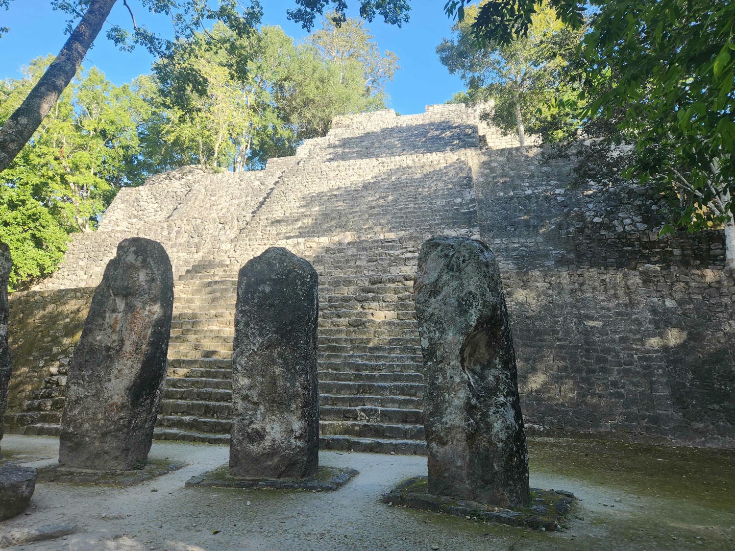
We headed off on Highway 199 north towards Palenque the morning of 1/6/26. We’d been told by several people that the road had some amazing views- and it did, but we thought that Highway 85 in Hidalgo and Highway 175 in Oaxaca, both north and south of Oaxaca City, were more scenic. The road was interesting, though, it that it brought us from the high pine forest of San Cristobal all the way down to the tropical lowlands. We watched the vegetation all day change gradually as we descended. One major complaint about this road were the topes– speed bumps. They were everywhere! In perhaps 5 hours of driving, we didn’t go more than about a quarter mile without passing one. They were also the hard, sharp kind- unlike the broad, gently sloping ones that are more common here. The topes and the curves of the road made for some stressful driving, and we were pretty bushed by the time we got to Palenque.
Palenque has two levels of access: the forest reserve and the ruins. The forest reserve pass is good for 5 days, but the ruins pass is only good for one day. We bought the reserve pass and went to our chosen campsite for the night, Camping Michol. As with most tourist attractions, there isn’t a lot of free and open land around, so we decided to just pay- only 140 pesos a night for both of us. The campground was very run down, but we don’t need a whole lot- just a place to park!
Once we had paid, we set off to walk the Sendero Motiepa, or Moteipa trail. The isn’t any parking further up from Camping Michol, so we just walked the mile or two from the campsite. On our way up along the road, we saw our first monkeys of the trip- long-limbed spider monkeys swinging from tree to tree. It was a bit of a surreal moment- we’d driven to where monkeys lived!

Soon, we left the road onto the trail. It wound its way through the dense, thick jungle. Though it was a bright sunny day, the greenery high overhead made us feel like dusk was well on its way, even though it was only 3pm! At the end of the trail is a small pool, fed by a spring. The Mayans apparently used the spring, as there was ancient stonework defining the edges of the pool. We were suddenly startled by a terrible roaring sound- howler monkeys! It was incredibly loud, but we’ve heard that the sound carries very well in the jungle. They can be heard from miles away!


On our way back, we took a small side trail to our first Mayan ruin. It was a small pyramid, perhaps the size of a good-sized house back home. The vegetation had been cleared off, but it hadn’t really been restored. Again, it was a bit surreal- here was evidence of an ancient civilization, who a thousand years ago had walked where we now stood. We spent half an hour sitting on the pyramid, looking for birds and listening to monkeys. The howler monkeys could still be heard here!


We walked back to the campsite, and had our first of many hot, muggy nights. Even at 8:30pm, hours after the sun had gone down, it was still well over 80 degrees and very humid! We woke the next morning in a puddle of sweat and drove back out to the visitor’s center where we bought our ruins tickets. There were a ton of local guides hanging around, who were all quite pushy in offering their services. We’d been warned and ignored them. We drove back to Camping Michol, parked, and walked back up to the ruins entrance, which we’d passed on our walk the evening before.

We wandered up the path, crossing a beautiful creek and waterfall, before coming to the first ruins. It was a residential complex, with lots of rooms and passageways. The interior of the buildings were closed off, but we were free to roam crumbling walls outside. We were all alone- it was an incredible experience. We decided that we’d go see the main ruins first, before the majority of the tourists arrived, before hitting the smaller bits.


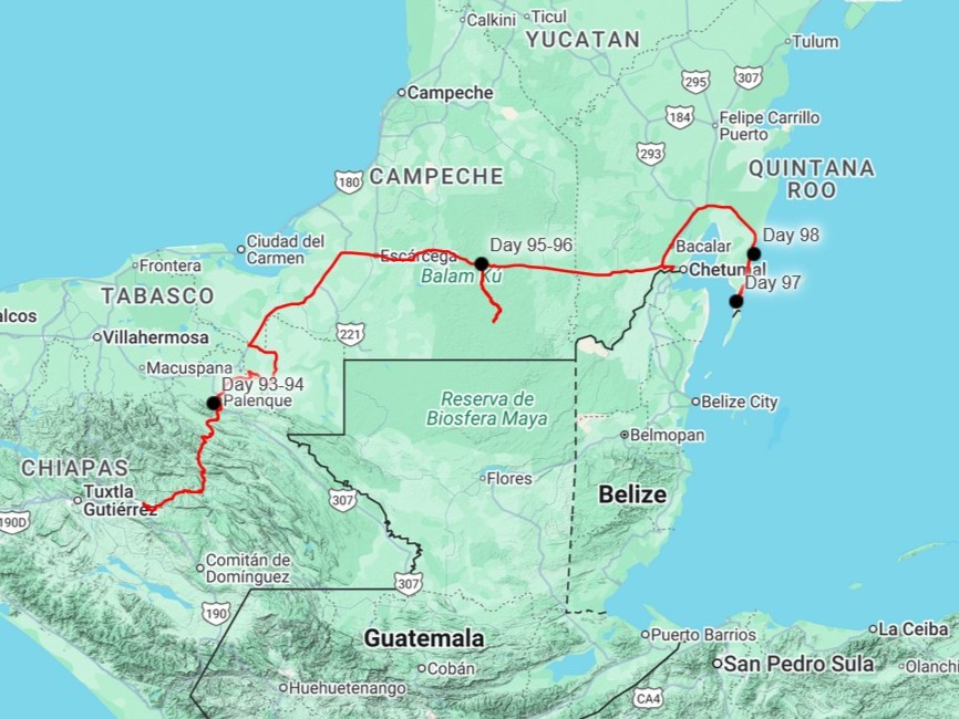
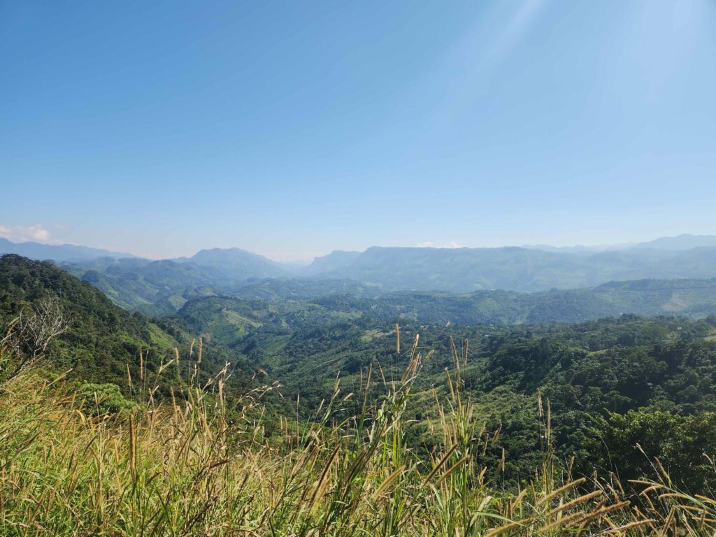
Palenque features a giant palace complex at the center, with massive pyramids surrounding it. We wandered around the ruins all day. Most of the pyramids could be climbed, affording an incredible view of the jungle around us. One of the pyramids could be entered, and we saw an ancient burial chamber inside, complete with a massive stone coffin. Other pyramids had rooms at the tops, with impressive carved murals inside. The palace had elaborate carvings all over, and of the pyramids had an interesting rabbit skull carved into it.


We have told each other time and time again that we aren’t going to be buying souvenirs on this trip- we simply don’t have the room. We’ve already broken this rule once at the Tlacolula market in Oaxaca, and we broke it here again. There are vendors everywhere along the paths between the ruins, mostly selling stuff that looks like cheap manufactured trinkets- model pyramids, bead hummingbirds, and paintings. We’re pretty sure it isn’t “authentic” local art because every vendor seems to have the exact same “art”! One vendor, however, was hand-painting feathers with images of all sorts of birds and animals- from memory! Some of the other vendors had these painted feathers, but they didn’t look nearly as good as this gentleman’s. We bought one with a bird called a motmot on it- the same motmot I’d seen that morning back at our campground! The feather is in a nice cedar frame with glass over the top- it might actually survive the jeep!


We also spent nearly an hour at a few massive flowering trees on the outskirts of the main ruins. We ate lunch here, lounging on an ancient stone wall, watching hummingbirds swarm the flowers. It was a wonderfully relaxing time well spent in the heat of the midday. As we walked out we passed by a few of the smaller ruins we’d passed by in the morning, and eventually made our way back down to the campsite. We spent the rest of the afternoon relaxing and trying to stay cool- it was seriously hot and muggy! I had a hilarious encounter with another tourist at the campground, a friendly Polish woman who looked super hippy. She was complaining that she didn’t like the “vibe” at San Cristobal, where we’d just come from, because it was “too hippy.” I asked her where she was going next, and she said she was meeting a friend in Oaxaca to help with some “mushroom therapy.” I stifled a laugh and changed the subject.
We left the next morning, planning on exploring the south-western corner of the Yucatan peninsula. I thought that it would be a bit more wild, but it was just farmland, with narrow strips of jungle in between fields. We were eventually headed to Calakmul, one of the largest Mayan ruins, and we’d planned on staying an extra night in between Palenque and Calakmul. However, with it being Thursday, meaning if we did spend an extra night we’d be visiting a huge tourist attraction on a weekend, we decided to just do a long drive day and visit Calakmul the next day, Friday. We were glad we did just decide to keep driving, as there was really nothing special in between. We camped just outside the Calakmul entrance gate, prepared to enter first thing in the morning.


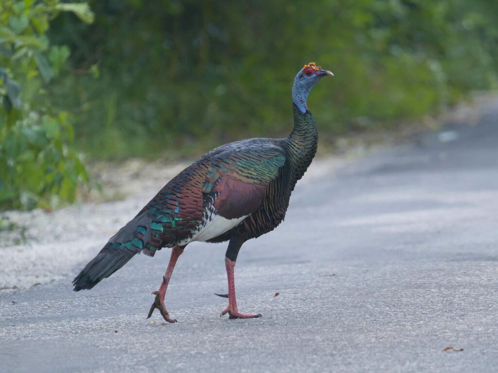
The road to Calakmul is a 2-hour drive from the main highway, and you aren’t allowed past until 6am. There is then another gate which you aren’t allowed past before 7:30am, and then finally into the ruins themselves at 8am. We woke up at 5:30, paid for our tickets, and began driving down the road. It is incredibly unlikely, but there are jaguars in the area, and it is usually the first car (as we were) that sees them! No jaguars unfortunately, but it was a beautiful drive through the jungle. We did see some Ocellated Turkeys, which are shaped a lot like our turkeys, but are colored very differently- blue, green, yellow, and brown! They slipped into the forest very quietly for such a large bird.
After a long drive through the jungle, we had timed ourselves perfectly- we reached the final entrance gate at 10 minutes til opening. We parked and went into pay our final fee- there are three separate entities to pay to enter. First, the Calakmul Biosphere Reserve, akin to our national parks. Then, the Ejido road fee, owed to those that own the land the Biosphere Reserve is on- don’t ask me how that works. Finally, there is the ruins fee, paid all the way down the road at the entrance. The fee had doubled since the year prior according to our online sources. We ended up paying in total 525 pesos each, about $30 US. It had been less than 300 pesos just a year ago! Palenque had been similarly more expensive than before. We think that it is because of the Maya Train.
The Maya Train, or Tren Maya, is a massive infrastructure project by the Mexican government that has been long talked about, but the previous president, Obrador, finally pushed it through. It connects Cancun, the hub of tourism in the Yucatan Peninsula, to most of the major Mexican Mayan sites around, in a huge circle around the peninsula. There is quite a bit of controversy about how it was built- among other things, it was designated a “national security” project to expedite permitting, funding, land acquisition, etc, despite being very obviously a tourist train. Regardless, Obrador was able to get the project finished before his term ended in 2024. The infrastructure built is quite incredible- the scope, scale, and quality of work far exceeds anything else we have seen for weeks.
Calakmul was one the two largest and most powerful of the Mayan cities. Its power and influence were at their highest during the “classic” Mayan period- after the Maya had established themselves as the dominant civilization in the area, by 250 A.D., and before the central part of the civilization mysteriously collapsed around 900 A.D. Calakmul and the other of the two most powerful cities, Tikal, now in Guatemala, seemed to be in a semi-permanent state of war with each other. One city would defeat the other and dominate the whole central Yucatan area every hundred years or so.


The reason we know so much about the ancient Mayans is because they had a written language, which was carved on monuments, altars, and the omnipresent stelae. The stelae are a sort of stone monument, roughly 8ft x 3ft, which are carved with a warrior, leader, or god. They were erected after important events, such as a war, or after a new leader had ascended. They usually were in front of pyramids or other important buildings. The reason the stelae are so important to modern archeologists is because most of them were dated with the famous Mayan calendar. The written Mayan language and the Mayan calendar were both deciphered in the 1930s. With all this information, archeologists know exactly what happened and when. Remarkably, we have massive lists of leaders for most of the many Mayan cities, with the years that they ruled, and often what they accomplished. Unfortunately, none of these stelae give any hint to why the Mayan civilization collapsed, in roughly 900 A.D. Nearly all the cities in the central Yucatan area were abandoned within just a few generations, including Calakmul, Palenque, and Tikal. Some cities stayed active until 1200 or 1300 A.D., such as Chitzen Itza near Cancun, and some even remained populated until the Spanish arrived in the very early 1500s, such as Lamanai in Belize. However, no stelae, monuments, or pyramids were erected by the culture after around 900 A.D., indicating a large-scale civilization collapse. Perhaps there is a stelae still buried somewhere that explains what happened!
Back to Calakmul. We were the first to enter, so we hurried to the central area so that we could explore before anyone else arrived. Most of the pyramids at Palenque could not be climbed, but there were no signs saying we couldn’t here! We climbed the first large pyramid we saw, and were stunned to see two larger pyramids just a few hundred yards away, across the tops of the trees. This pyramid was barely above the jungle canopy, but the other two certainly were! Before we headed down towards the other pyramids, we saw our first toucan fly through the trees, right in front of us. We truly were in the Tropics now!


Back on the forest floor, we headed across the main plaza, now full of giant trees. At Palenque, most of the jungle had been cleared from the area, but here it was mostly as it had been found, with just the larger buildings cleared off. The largest of the Calakmul pyramids is apparently one of the largest pyramids by volume on earth, mostly because of its massive base. While only perhaps 10ft high, it covers an absolutely massive area. We continued with the “Mayan stairmaster” as we’ve been calling it, and headed on up. Most of the large Mayan pyramids are “stepped”, with small platforms and buildings on each of the steps. The buildings are mostly ruined now, but you can still see the walls, passageways, and sometimes the ceilings are still intact.


When we finally reached the top, we were speechless at the view in front of us. We were high above the jungle canopy, and could see for miles in every direction above the trees. It was as if we were on a ship at sea, gazing out over the ocean. The ground was shockingly flat, with almost no topography at all- only a slight depression to our west, and a slight bump on the horizon to our south, which I’m fairly certain is in Guatemala! We were only about 20 miles from the border. We stayed up on top for almost 20 minutes, looking at the tops of some of the other monuments through the trees below, and looking out over the jungle.


Back at the bottom, we looked over some of the other buildings and stelae before climbing the other main pyramid, which had a similar view as the first. It was incredible to be sitting where people from a city, abandoned for nearly 1200 years, had once been. For the rest of the morning and early afternoon, we explored the entire site. There were massive open plazas, perfectly flat, where there had probably once been markets and celebrations. There were palaces, where the royalty had lived. There were buildings called acropolises which had probably been civic centers or businesses. There were also, on the outskirts of town, residential complexes. Each complex was composed of perhaps 8 buildings, all facing a small central plaza. These are theorized to be family residences, where several generations of an important family would all live together with a central common area.


While much is known about how the rich and important lived, comparatively little is known about how common people lived. It is likely that they lived on the outskirts of town, in buildings that had only stone foundations, or perhaps no foundation at all. The buildings would have been framed with wood, with walls and roofs made of grass or palm leaves. It is likely that the Maya had a large rural population of farmers, laborers, and craftsmen, who did not necessarily live in the massive stone cities.


After we felt we’d explored all the major buildings, we headed towards the exit. We were stopped by a bunch of screaming monkeys high overhead- there were 15 or 20 of them, all swinging from tree to tree and squabbling with each other. We sat and watched them for half an hour. There were adults, mischievous juveniles, and tiny babies carried by their mothers. It was an incredible sight!


We had skipped the museum on the way in, and now spent the last hour of our visit reading the signs (in English!) which explained the history of the city, as well as how it was discovered and uncovered. There are sadly very few artifacts in the museum- it seems that they have all been shipped off to the big museums in Mexico City, or further abroad by earlier foreign archeologists. After the museum, we ate a very late lunch in the parking lot. We were quite hot, sweaty, and hangry after climbing every climbable monument and walking for miles through the jungle.


On the long drive back to the main highway, we stopped at a pulloff and saw our first army ant swarm- it was incredible! We could literally hear the tiny ants swarm across the jungle floor. Hundreds of them would climb a tiny tree, like a wave up a beach, and after checking every branch, the wave of ants would ebb back to the ground. Insects like centipedes and grasshoppers would flee the horde of ants- but often the grasshoppers would hop right into the middle of the swarm, and some wouldn’t make it back out. It was absolutely fascinating seeing in action what I’ve watched in nature documentaries back home. Our only other stop on the way out was a short trail around a small lake, which was uneventful other than seeing a type of Brocket deer, which looks like a small whitetail.


We camped along the main highway, which had recently been rebuilt. The old highway was abandoned, and though it was close to the new highway, we were so tired that the road noise didn’t matter at all. We had a great night’s sleep and were ready to go the following morning. We continued east across the center of the Yucatan Peninsula, and watched the impenetrable jungle fade away to farmland as we got closer to the coast. Before reaching it, we turned north towards Bacalar, which is a popular vacation destination for locals. Bacalar is on the shores of a massive freshwater lake, which due to its proximity to the ocean, has beautiful white sand beaches. It is unfortunately very populated and very touristy, and we had already planned on continuing on to an area with fewer people. North of Bacalar, we turned east towards Mahahual on the coast. The terrain was interesting- our first look at a mangrove forest. The road was not so interesting- straight and flat for almost an hour. Before reaching Mahahual, we turned south towards a likely camp spot, an old boat launch just a few miles north of the Belize border. The road south from Mahahual was also straight and flat, but also narrow, quickly being overtaken by the forest. After another hour, we turned off to a small side road, and then another smaller one, adding a few pinstripes to the jeep before we popped out at a tiny clearing at the edge of the ocean- our first look at the Caribbean Sea!


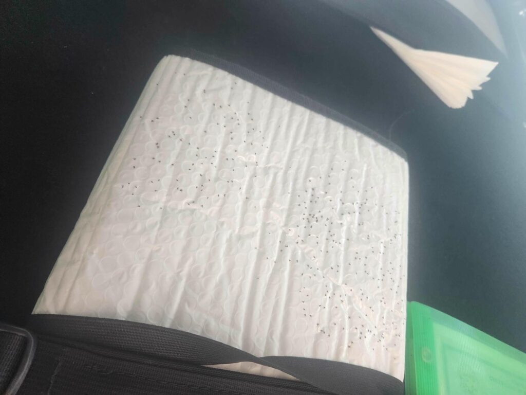
It was blue, calm, and shallow. We were on the shores of a massive lagoon, the Bay of Chetumal. We had a wonderfully relaxing rest of the day, really not doing a whole lot. We were pretty exhausted from our frantic pace the last few days- two major Mayan ruins in three days, with the middle day being a long drive day. We were hoping for a relaxing night as well, but as soon as dusk hit, the bugs were out in force. Even though we moved the jeep a bit in hopes of getting to a less-buggy area, turning on the headlights revealed the problem we’d gotten ourselves into- there were literally thousands of bugs in the air. They were mostly sand flies, which are also known as no-see-ums or chiggers. They are teeny-tiny, small enough to get through our bug mesh, but their teeth aren’t teeny-tiny! They can actually draw blood, despite being smaller than a pinhead. They were even getting through our closed doors, right through the door seals. While putting bug spray on (you shouldn’t need bug spray for sitting INside your car), I noticed that a bunch of the sand flies were landing on the white inner lining of our windshield shade, which we keep tucked up above the driver’s seat. They really seemed to like landing on white surfaces. In a fit of frustration, I sprayed the bugs directly, killing the 10 or 20 that had landed there. A few moments later, I looked up, and noticed that they had continued to land there- but that the bug spray was killing them! By morning, there must have been 200 dead no-see-ums on the windshield shade. Absolutely disgusting.
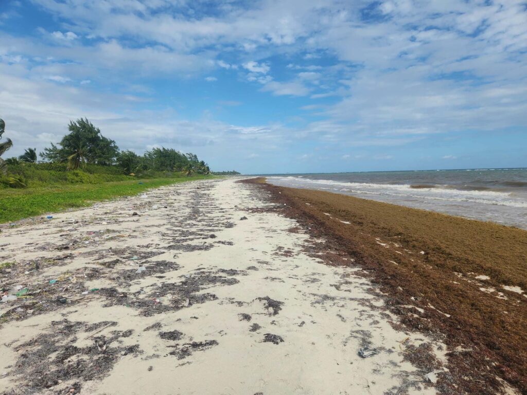
We had a bit of a fitful night’s sleep- even with bug spray, our fans pointed right at us, and a light sheet over us in the muggy heat, we could still feel the tiny bugs biting us and buzzing around. The next morning, we resolved to move spots. We had planned on staying 2 nights in this area, but even without the bugs, the spot wasn’t terribly pleasant. There was no breeze off the lagoon, and the lagoon itself wasn’t terribly inviting to swim in. It was very shallow, and the bottom wasn’t sand- more like mud. The mangrove forest also precluded any exploration around the area. After driving through Xcalak, the tiny beach town on the open ocean side of the peninsula we were on, we eventually found a spot on the coast about 10 miles south of Mahahual. It was much better- a constant breeze off the ocean kept the bugs down! Unfortunately, we still couldn’t go swimming due to the huge amounts of sargassum seaweed that plagues the Caribbean coasts this time of year. There were thick mats of the stuff piled up on the beach, and all the way out past the breaking waves.
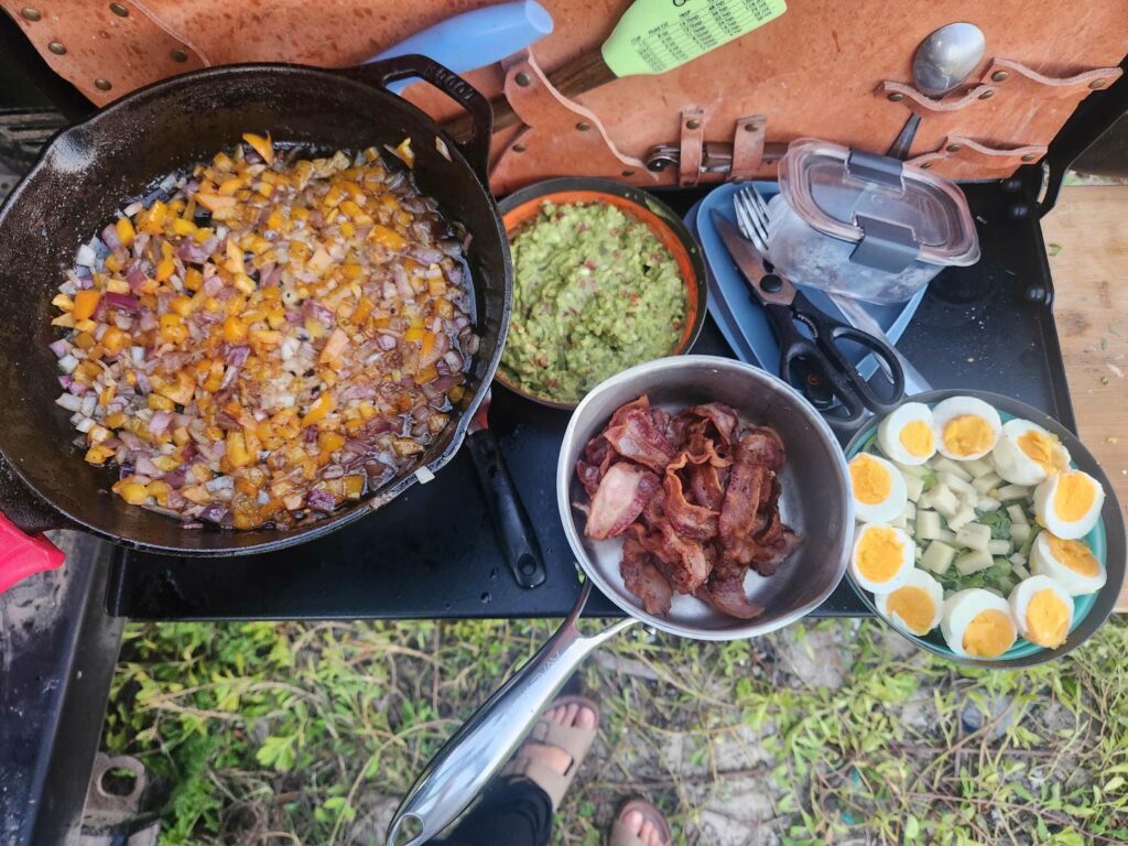
We had a great day anyways, catching up on important things like making Instagram videos and editing bird photos. We decided that we’d cross into Belize the following day, instead of staying another night closer to the border. We were only about 2 hours away, and though we like to hit borders first thing in the morning, this one wasn’t supposed to be difficult. Delaney made an incredible dinner, trying to use up all our fruits, veggies, and meat- you can’t cross borders with any perishable groceries. We slept great with the sea breeze keeping us cool all night long- our first cool night’s sleep since San Cristobal.

The next morning, we made breakfast with the last of our veggies and eggs, and hit the road. We drove back past Mahahual, and then the long boring straight hour through the mangroves to Bacalar. We stopped in Bacalar for fuel, and then had a bit of a wild goose chase finding a bathroom and an ATM- Delaney is keeping one of each country’s bills and coins, and we’d spent our last 500 peso bill at Calakmul! 500 peso bill secured, we headed towards the Belizean border.