Today was January 12th, 2026, our last morning in Mexico. We’d been in Mexico for nearly two months, since November 19th. We have absolutely loved Mexico, and wish we could stay for longer- but if we’re to be in Patagonia by our target time of Winter 2026/27, which is summer in the southern hemisphere, we can’t stay anywhere for too long.
For the curious, here’s some statistics from our time in Mexico:
Miles driven: 4,616
Gallons of fuel purchased: 315.443 gallons
MPG in Mexico: 16.2 (adjusted for entering Mexico nearly empty and leaving full to the brim)
Nights wild camping: 34
Nights paid camping, including at attractions like Maya sites: 16
Nights in a real bed (Mireya’s condo in Baja, Mazatlan hotel): 3
Nights on a ferry: 1
Total nights in Mexico: 54
# of times we felt unsafe: 1, the Fitosanitaria stop in Sinaloa, which was probably not dangerous
I’ll add some parting thoughts about Mexico: it is an amazing country. The natural beauty is astounding- beaches, mountains, deserts, waterfalls, canyons, volcanos, jungles, caves, cliffs, and on and on. The people we met were wonderful. Even when we would meet people who would, for our American standards, aggressively attempt to sell us something, we never felt threatened. The food in Mexico is unbelievable. I really haven’t liked any of the so-called Mexican food that I’ve had in the U.S. It’s just beans, rice, and some stuff in a tortilla. However, after being here for two months, I now know that I’d never had real Mexican food before. I’ve now had real street tacos, authentic Oaxacan cheese quesadillas, birria tacos, mole, gorditas, tacos al pastor, empanadas, queso fundido, and Mexican pastys. I’m sure you can get real Mexican food in the U.S., but I’ve never had any. I really don’t care for cooking, but I can’t wait to try and make some of the things I’ve had here. The driving in Mexico was not as bad as I expected. It is certainly very different from the U.S. and it took us a bit to adapt, and it is far more chaotic, but once you understand how things work it really isn’t bad. The drivers here are much more skilled and courteous- for example, a 4-way stop in Mexico is just as efficient as a roundabout in the U.S.! We both loved Mexico, and we will be back. Unless we like somewhere else more, Mexico City will probably be our first real vacation after we start working again!
Enough about Mexico: on to Belize! We were now leaving North America, and entering Central America. Our first stop was to officially leave Mexico. Our passports were stamped out, and then we parked to export the vehicle, which had been “temporarily” imported to Mexico. After a bit of a wait, and an impressive amount of paperwork, we were returned our $400 deposit we’d made in Tecate, and we were off through “no man’s land” to Belize. The first step to enter Belize is fumigation, where they spray the vehicle to supposedly kill any insects that may be hiding on the vehicle. We’d already been through this once while crossing from the state of Baja California to Baja California Sur, and had some misgivings about its efficacy. Fortunately, as is well documented by other travelers, all that Belize really cares about is that you pay for the fumigation, not that the vehicle is actually fumigated! We had intended to try to bypass the spray anyhow, but we were actually waved around it by the guy running the place. It was wonderful to be able to converse in English. Belize is officially an English-speaking country, though they all have a thick Caribbean accent- a lot like Jamaicans.
After paying for fumigation and getting the receipt which would be needed for a later step, we parked at the main Immigration office, filled out a short form, and were stamped into the country. We had to give an address for where we’d be staying, and rather than try and explain that 1) we had no idea where we’d be staying and 2) we wouldn’t be staying anywhere with an address, we just gave them the address to a hotel we found on google. Turns out that’s all they needed- they are just checking a box in the long list of paperwork they have to do on their end. After getting ourselves stamped into the country, we needed to get the vehicle temporarily imported into the country. We moved down to the Aduana booth, also known as Customs. The worker here was the first of many border workers I am sure we will encounter who is simply “over it”. During our stop at her booth, she remained leaned back in her chair, and despite me clearly not being able to hear her, she refused to get closer to the perforated plexiglass between us or raise her voice above a mumble. I ended up basically pressing my ear up against the plexiglass the whole time. A bit frustrating, but I suppose government workers are the same the world over. Despite our communication difficulties, we were eventually given our TIP, or Temporary Import Permit. We then drove through the official border, where our passports and vehicle paperwork were checked. The military guy there did a very cursory inspection of the inside- all he did was open up our fridge. We only had one final stop- insurance. The workers in the insurance building were very friendly, and they had an impressive “sticker wall” inside, where all sorts of travelers would leave their sticker. We haven’t done this, but it seems that a large proportion of overlanders have stickers that they leave at popular places like border crossings and road signs. It’s been fun to see some from people that we recognize from YouTube. We purchased 2 weeks of insurance for 46$, knowing we’d probably only stay a week.
Our next stop was to restock on some groceries, as our fridge was pitifully empty. We headed to Corozal, the closest town to the border. It was a small town with only a few stores, but we found a store that had the essentials- some meat, noodles, and eggs. We also had to sample some of the drinks- Belize has some of the same brands as the U.S., like Coca-Cola and A&W, but with different varieties. Ice-Cream Sundae A&W root beer was pretty good, but green apple Fanta was disgusting. After restocking, we headed out towards a point that looked like it would be possible to camp at. We quickly noticed that the speed limit signs here were in MPH, which was very strange as we’d finally adjusted to kilometers in Mexico.


We drove most of the way to Sarteneja, before heading north to the coast. We found an abandoned lot right on the ocean that had been cleared, but nothing had been built on. We were now on the south side of the lagoon that we’d camped on the night before last, and this side was much more pleasant. Far fewer bugs and far better swimming! We had a great evening and night here.


We had noticed the day before, and we noticed again the next morning, that while the terrain was the same, the culture was very different. Belize is a former British colony, unlike Mexico and the rest of Central America, which were settled by the Spanish. As we drove through the back roads headed towards Progresso, we followed a school bus picking up schoolchildren. I’m not sure if we saw a school bus with schoolchildren in all of Mexico! The children were all in uniform, which was also very different than Mexico. Another thing we quickly noticed was that more buildings were built out of wood. I’ve written here before about how the Mexicans build everything out of concrete, so seeing wooden buildings for the first time in months was very different!


Belize also has a very large Mennonite population, and they definitely run a tight ship. Their farms are all very well kept, with hedgerows and pruned trees. They look just like Europeans, in stark contrast to all the other locals who are mostly indigenous or mestizo. Their clothes are also different- overalls and bright button-up shirts for men, and bulky black dresses for women. Horse-drawn carriages were a common sight in the Mennonite areas, though they also seemed very fond of 1st and 2nd generation Dodge one-ton pickups. We’d seen a few of these in Mexico, but they’d all had gasoline engines. The Mennonites all had diesels! This particular truck is famous for having an engine that is 100% mechanical- no electronics at all, unlike all other American diesels since the early 1990s. I don’t know much about the rules that Mennonites live by, but perhaps the lack of electronics makes them able to use these particular trucks, but not the more common Fords?
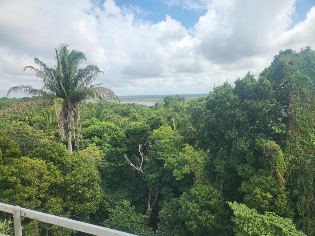
After a few hours down back country roads, we arrived at the Mayan ruin of Lamanai. Lamanai is famous for still being inhabited when the Spanish arrived in the very early 1500s, though the people living there had long since stopped erecting the massive stone structures that the Mayans are famous for. As with Calakmul and Palenque, the entrance price had doubled in the last year! The person at the entrance said it was due to cost of living increases, but I’m not so sure- after talking to some other people about this same issue, it seems that entrance prices to most of the Mayan sites in Mexico, Belize, and Guatemala have doubled every year for the past few years. Perhaps they’ve realized that foreign tourists will pay just about anything to visit these sites, especially when an increase from an equivalent of $5 to $30 doesn’t really phase Europeans or Americans. Anyhow, the Lamanai ruins were not as impressive as Calakmul, but we really enjoyed the site. It felt more open to exploring than Palenque or Calakmul had, and we had the place all to ourselves for the first 2 hours before other tourists started showing up.


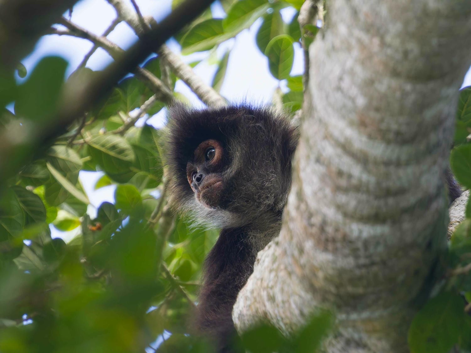
Not all the ruins had been uncovered, but the large and interesting ones had, and they were all climbable. The largest pyramid had a great view of the nearby river that Lamanai was built next to, and we sat and watched monkeys play in the trees as parrots chattered away in other trees. All the Mayan sites have had so much wildlife- parrots, spider and howler monkeys, tapirs, toucans, and more!


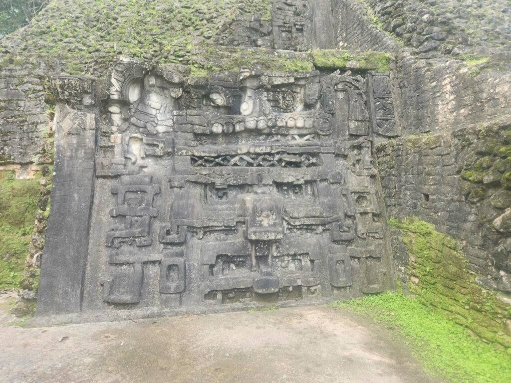
The northernmost uncovered structure at Lamanai was a smaller pyramid, but it had two giant faces carved into each side of the main stairway, each taller than Delaney or I! We overheard a nearby tour guide explaining how they were discovered- the Mayans, over successive generations, would build new pyramids right on top of the old ones, covering up all sorts of carvings and stucco sculptures. It has preserved many things that would have otherwise decayed in the wet climate. However, once the faces were uncovered, they are once again subject to decay, so the real faces were removed, and the ones here are replicas! They were very convincing replicas, and the tour guide knocked his finger on them to show how they were made out of fiberglass and plaster. In the other Mayan sites we’ve been to, we’ve found that quite a few of the carvings and stelae are fiberglass replicas. The replicas are very good but I wish that they would keep the real ones on site- most are in museums in the larger cities, or taken abroad by the early archeologists.


After a leisurely walk back through the ruins, we spent a good long time in the on-site museum. As Belize is English-speaking, all the signs and posters were in English, which was a welcome change from trying to decipher Spanish signs. The museum was very well done, with lots of informative displays, and far more artifacts from the site than the Mexican ones. It seems that most of the artifacts from any of the Mexican archeological sites we’ve been to, Mayan or not, are either not on display or have been whisked away to giant museums in Mexico City. Because Belize is so small, a country of only 250,000 people, most of the artifacts were here. There were clay pots with amazingly complex faces and images sculpted onto them, jade beads, obsidian knife blades, and more. One thing that was not on display was one of the most important discoveries at Lamanai- an offering found below the ballcourt. There was a clay bowl still full of liquid mercury, with pieces of jade and obsidian floating in it!


After Lamanai, we drove back to the main highway, and headed south. We found a larger grocery store than the tiny one we’d found at Corozal, and stocked up on some fruits, veggies, and we even found some Oreos and Pringles- it’s been a while since we had American snacks! We also picked up some of the Belikan beer we’ve seen advertised everywhere- Belize’s most popular local brew. We drove further south on the main highway, and the Mennonite farms faded away, replaced by small towns with people who looked more Caribbean or Jamaican. Belize had been quite flat until now, but we started to see some pointy karst hills on the horizon- an unusual limestone topography that is common here and in parts of China. It has been very interesting seeing landscapes that are formed not by glaciers, but only water and wind! Gone are the massive U-shaped valleys and rounded hilltops of Montana and Colorado, replaced by narrower V-shaped valleys and pointy hills of the tropics.
We found a small road that led down to a river with an awesome swimming hole below a highway bridge, and though it was close to the highway, we were mostly out of sight. It seemed like a popular local spot, but everyone was very friendly and we felt safe enough to spend the night. That evening, Delaney booked a last-minute snorkeling tour out of Hopkins for the next morning. We’ve wanted to go snorkeling again ever since our amazing experience in Huatulco, Oaxaca! We woke early the next morning and started in on the 2-hour drive. We arrived at the Marina just in time after first going to the wrong place, ahead of the other couple on our tour, Belgians Emile and Sarah, who had made the same mistake. We took a 45-minute boat ride in a small skiff out to one of Belize’s many long, narrow, offshore coral/limestone islands, called Cayes, and then transferred to a smaller boat. We were then taken out to the seaward side of an underwater reef, before donning fins and masks and jumping out of the boat. The water here was much deeper than where we’d gone in Oaxaca, but it was still amazing. We saw all sorts of fish, including a menacing-looking barracuda. This reef seemed much more alive than the one in Oaxaca, with more underwater plants being pulled and pushed back and forth by the swells. After about half an hour of swimming around, we climbed back into the boat and were taken back to the island for a quick lunch of chips, salsa, and pineapple.
Our next snorkel location was on the “land” side of the reef, which was more sheltered and shallower. We saw lot more sea life here, including a nurse shark and several rays! The rays were gigantic, perhaps 4 feet across and 6 feet long, including the tail. We made sure to keep clear of the rays- they’re quite gentle, but the tail includes a poisonous spike that can be deadly if they are provoked. There were also a lot of larger fish here, albeit slightly less colorful than Oaxaca. After another 45 minutes in the water here, we were taken back to Hopkins. We had an amazing time and are very glad we made the last-minute decision to book the tour! It was great to talk to Emile and Sarah for the day- we ended up giving them a ride back to where they’d stashed their bicycles.


We headed back to the same campsite we’d been at the day before, intent on taking advantage of river water to take a bath and to do laundry. We fell asleep exhausted after swimming all day, and had a great night’s sleep. The next morning, we did laundry and jumped in the river to clean off yesterday’s salt water, as well as the grime we’d accumulated since our last shower in Palenque. There were tons of small fish in the river, who were all very interested in us, and would nibble at our feet and legs! I also soaked my painfully itchy hands and feet, which the biting insects just seem to love. After our 2nd-to-last night in Mexico, my right hand especially has been super swollen from all the bug bites. We also met a local, Mikey, who had come to the swimming hole with his kids to let them blow off some steam. He was from Punta Gorda, the southernmost city in Belize, where we’d been thinking about visiting the next day. We asked him what we should do there, and he replied “hm… well…. huh… I guess there are some Mayan ruins nearby.” Not a glowing endorsement! We decided to skip Punta Gorda.


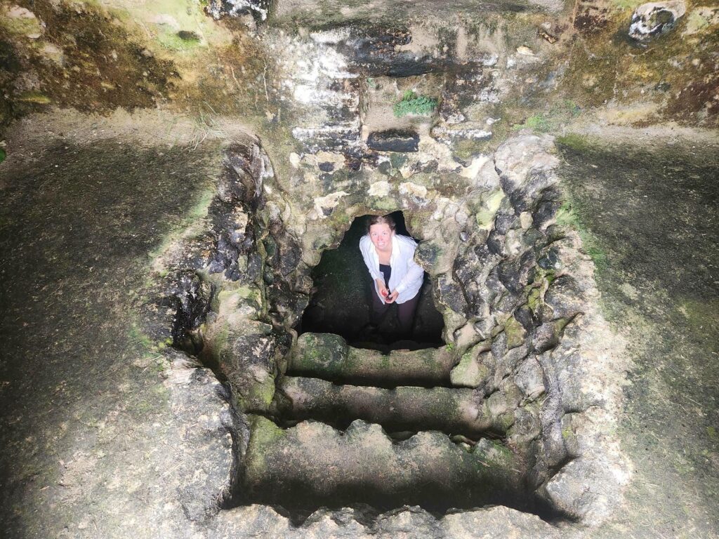
After our laundry had mostly dried, we headed inland. We drove up the Hummingbird Highway, famous for its scenery and terrain. Some of the jungle roads we’d driven in Mexico were far more impressive, but it was still beautiful! We climbed through banana, citrus, and coconut plantations, passing through some of the most vividly green vegetation I’ve ever seen. We stopped at St. Herman’s Blue Hole National Park, and went on a short hike to a cave with a river running through it. The cave entrance was a sinkhole, and the water coming out of the cave continued on into the darkness. We were allowed to walk about 750 feet into the cave without hiring a guide, and we walked along marveling at the stalagmites and stalactites. We were all alone at the back of the cave, and turned our headlamps off for a few minutes. The darkness was overpowering- we couldn’t see a single thing, even our own hands inches from our face.


After the cave, we drove a few miles to the other side of the park to visit the Inland Blue Hole, another sinkhole, this one flooded to the rim. The sinkhole is shallow on one end, but apparently 100 feet deep on the other, and we took turns trying to touch the bottom further and further out. I made it pretty far down, further down than I did while snorkeling the previous day if the pressure on my eardrums was anything to judge by! On the way out, we followed a massive trail of leafcutter ants, which had cleared a path nearly a foot wide from any vegetation. The path of ants led up from the sinkhole, past the entry kiosk, and up the very tree we had parked under! Our jeep had little bits of green leaves on it, from clumsy ants dropping the pieces they were cutting.


We continued up the Hummingbird Highway and turned into the Mountain Pine Forest Reserve, a pine forest in the Maya Mountains, a small mountain range in western Belize. We found an amazing campsite on an exposed ridge. Finally a respite from the oppressive heat of the lowlands! We had a great night’s sleep with a wonderful breeze.
We woke fairly early the next morning, intent on beating the hordes of tourists our next destination, Caracol. Caracol is yet another major Mayan city- we sure are visiting a lot of these! It is one of the better studied cities, with yearly visits from the University of Houston since 1985. It was supposedly one of the most densely populated Mayan cities, with a population of possibly over 150,000 people. Belize has only 250,000 people in the entire country today, and the largest city, the capitol, has only 65,000 people. I will never not be amazed at how huge and impressive the Mayan civilization was- millions of people living in an area that is now impenetrable jungle with very few people.


We arrived to the site and were only the 2nd vehicle in the parking lot. Caracol was the first Mayan site we visited where prices hadn’t doubled- only about $25 for both of us to enter. As with the other Mayan cities we’d visited, we headed for the biggest pyramid first, hoping to have it to ourselves before it became covered with other tourists. We were successful and had over a half hour on top all on our own. This pyramid, called Caana or Sky-Palace, is absolutely massive. It has several terraces on the front side with buildings on them, and then the top of the pyramid has 3 separate pyramids on it, all facing a central plaza. It felt like the largest of all the Mayan pyramids we’ve climbed before or since- it was just unreal how huge it felt. Each of the 3 pyramids on top of the main pyramid were the size of a small house. Despite being built at least 1300 years ago, it is still the tallest building in all of Belize at 141ft!


We continued walking through the site, marveling at the now expected collection of pyramids, ballcourts, palaces, residential complexes, and acropolises. We were now starting to recognize these features on our own, and could also recognize how similar in construction they were to the other sites we’d been to. All the arched ceilings were built in the exact same way in Palenque and Calakmul, with the same angles, rock sizes, and wood bracing. It is mind-blowing to me that a civilization that had no beasts of burden or wheels could share so closely a construction style across hundreds of miles of impenetrable jungle.


We stopped at the museum on the way out, which had collected most of the stelae found on site and had them on display. Like Lamanai, there had been fiberglass replicas placed all throughout the site where they had been discovered, but all the real ones were at least still here. Most of them have deteriorated significantly since they were carved, as they were made out of fragile and water-soluble limestone and sitting in the jungle for 1200 years before they were re-discovered, but some were well preserved.


We really liked Caracol- it was our favorite ruin so far. It didn’t have the pushy guides of Palenque, it was more cleared off and open than Calakmul, and the main pyramid was in our opinion the most impressive structure so far. The main pyramid at Calakmul is taller by 40 feet, but Caana was far more imposing and appeared more physically massive to us.

After a long day of walking around Caracol, we headed back to our previous campsite. The campsite was in a network of logging roads, and I tried to get there via a more roundabout way, but the other roads were far smaller and narrower. We eventually made it through a different back way, after some muddy climbs over long-forgotten roads. We’d hoped for a quiet relaxing evening outside the jeep, but the camp spot had become overrun by our old enemy- no-see-ums. The rain also came in, alternating on-and-off with the bugs to keep us cooped up in the jeep for the next 2 days. We’d planned on staying at this spot for a bit but we hadn’t planned on being so sedentary!
We caught up on some much-needed sleep, still not recovered from our breakneck pace the last 2 weeks. I made some minor repairs, including repairing my jerry-rigged laptop charger- I hadn’t been able to charge the laptop for the last 2 or 3 weeks! We’d planned on exploring some of the other destinations in the pine forest we were in, which included caves, sinkholes, and waterfalls, but the weather, bugs, and our exhaustion kept us from doing too much. It was our first time slowing down since the campground back in El Tule, Oaxaca.


We were only about 2 hours from the Guatemalan border, so we didn’t have to find another campsite before crossing. We drove down through San Ignacio and started the process of leaving Belize and entering our 5th country of the trip, Guatemala.

What an amazing trip this has been to hear about. It is very interesting to hear how you are seeing the similarities in the construction styles in different locations. You are not just tourists, but observers. Thanks for keeping us updated and a very enthralling narrative.
Miss you guys!