We’d just crossed out of Nicaragua, and now had to enter Costa Rica. The Costa Rica border facilities were brand new and very nice. We stood in line for a bit and were then stamped in. We then had to go through a sort of airport security apparatus, which we thought was a bit funny- we could have just left everything in the jeep, which wasn’t searched on the Costa Rica side! After getting stamped in, we then bought insurance for the jeep before doing the TIP paperwork. The TIP officer couldn’t be bothered to exit his air-conditioned office to search the jeep, so we were now free to drive on.
We drove on into Costa Rica, and passed a 10km long line of trucks waiting to enter Nicaragua. They can wait in line for several days to cross the border. We are continually thankful that cars and motorcycles are always allowed to go right up to the front of the line, for all the borders we’ve crossed so far. We stopped at the first town we came to, Liberia, to stock up on food, Costa Rican cash (“colones”), and gas. The gas station attendant noticed the flag stickers we have on the jeep for each country we’ve entered, and couldn’t believe it when I put on the Costa Rican flag right there and then!
Delaney really wanted to try to surf and had arranged for us to take surfing lessons. As we left Liberia, we passed by the airport and were surprised to see an Alaska Airlines plane there. Liberia is their second-furthest south destination, with the southernmost being the capital city of San Jose just a bit further along. It was cool to see a tiny slice of home here! We drove through some flat and relatively arid farmland before getting into some hills further along, which were if anything a bit drier. After a few hours of driving on smaller and smaller roads, we finally made it to an excellent camping spot that Delaney had found online, along a wide riverbed. Thanks to the capability of the jeep, we were able to drive down the riverbed a few hundred yards and be out of sight of the road.
We arrived at our camp spot around 4pm, in some incredible heat. We explored the riverbed a bit, trying to get down to the beach, but the underbrush was too thick to walk through, and the river a bit too deep and scary to cross- there are crocodiles here! Thankfully we’d parked the jeep in the shade, and it eventually cooled down a bit, but not enough. It was a very hot night.
The next morning, we drove a short distance to a surfing beach and met our surfing instructor, Paco, a French ex-pat. He was a good teacher and we soon learned how to catch a wave, stand up on the board, and ride it to the shore. It was another scorchingly hot day and it felt great to be in the water. Surfing wasn’t quite as difficult as I thought it would be, but we were just surfing little waves- I’m sure the difficulty goes up exponentially with larger and larger waves. If we liked beaches more I’m sure we’d be doing a lot more surfing!


After our surfing lessons we stopped at a bar in town to have a quick beer, but the place was very strange- almost entirely elderly foreigners, with the only locals being the staff. This area of Costa Rica is extremely touristy and we disliked how the huge numbers of foreigners have completely changed the composition of the area. This includes the prices- I think we paid nearly $5 each for a single Corona, which is normally only a dollar or two! We then drove back to our previous camp spot in the riverbed. Delaney was extremely motivated to work on some chores- washing the jeep, doing some laundry, etc, but I wasn’t doing so well. The heat was really overpowering- over 100F, and I really couldn’t manage to do much more than sit around. Delaney did a bunch of laundry, which felt really good to get done- we hadn’t washed most of our clothes since Copan in Honduras. The sun dried everything very quickly.
We were chased out of the jeep early the next morning with the rising sun- it got hot out almost immediately! We drove down the coast to Samara, which is another tourist town, but we’d gotten a recommendation from one of Delaney’s friends for a breakfast place. She had lived here for the past year or so and had left only a few days before we got there! The breakfast place was wonderful- a local spot with delicious food.
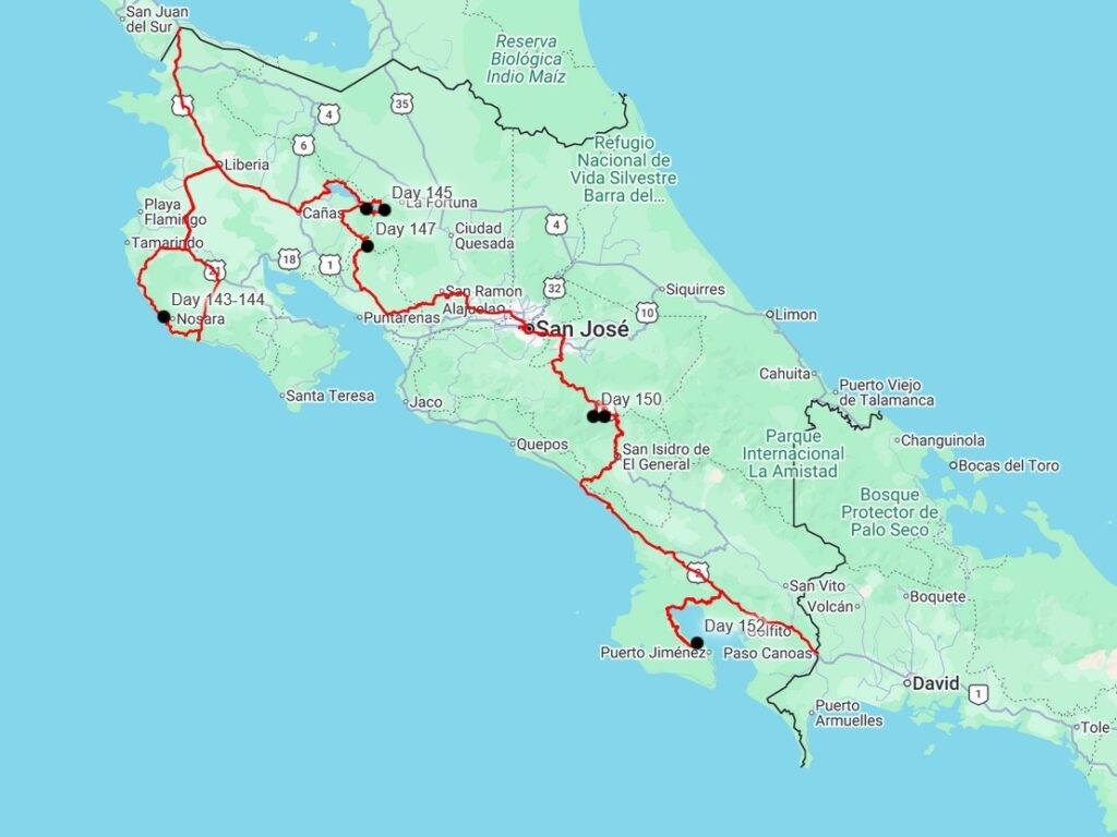
We headed back to Liberia, through some rather boring countryside. The only exiting part was the highway bridges- the road was a two-lane highway, but the bridges were all only one lane, and usually on blind corners! There was usually a small game of “chicken” to see who would get to cross the bridge first. We drove into Liberia and met Dominic at the DHL office- our drone had arrived from Honduras! Our drones had arrived safely. We warned him about the heat- he and Pia were headed down to the beach where we had just been. Delaney and I found a nice grocery store and stocked up before starting a long drive headed east. We started off on the main Highway 1 out of Liberia (the official Pan-American highway) before turning off at Cañas north towards Lake Arenal. Lake Arenal is a popular tourist and vacation home area due to its higher elevation- it was noticeably nice and cool out!


The lake was simply gorgeous to drive around, with all sorts of nice restaurants (mostly German for some reason) along the way. The road was well paved but very windy and wet, which slowed us down quite a bit. Just as the sun was setting, we came across a short line of stopped cars. I hopped out and walked to the front of the line to see what happened, where I saw that a small pickup had gone off a short bridge. A heavy wrecker had just got it back up onto the road, so we didn’t have long until the blockage cleared. The truck didn’t look too bad- it looked like it had landed in the stream below the right side up at least.
We were headed to the Arenal Observatory Lodge, a private nature reserve on the side of Arenal Volcano. The volcano erupted almost continuously from 1968 to 2010, and the lodge became one of the best places on earth to watch an active eruption during that time. Since the volcano has gone dormant, the lodge has pivoted to being a nature and birdwatching destination, which was why we were here. We camped on the road leading up to the lodge, and entered at sunrise the next morning. The lodge has a large feeder that they fill with fruit every day, which entices some of the more difficult-to-see birds out of the underbrush. There were massive turkey-like Guans, chicken-sized Chachalacas, beautiful tanagers of all colors, woodpeckers, sparrows, and hummingbirds. Adorable racoon-shaped Coatis picked up the dropped fruit from the ground. It was a magical morning and we saw all sorts of birds that are normally quite stealthy.


After enjoying the feeder for a while, we started off on the hiking trails. The lodge has miles of trails through the jungle, as well as trails through a sort of hobby-farm area. We also climbed one of their “canopy towers”, much like the tower that we climbed after seeing Tikal in Guatemala. It provided an awesome view over the top of the jungle, though the volcano was sadly in clouds the whole time we were there.


We spent several hours wandering around, seeing very few other people. Areas where you can walk in the woods without seeing many other people are quite difficult to find in Central America, and we enjoyed every moment of it- especially the wonderfully cool weather. We also saw 75 different kinds of birds in the 6 or so hours we spent there, and I nearly filled up the memory card on my camera with all the photos I took.


After our time at the lodge, we wanted to head to Monteverde, a nearby area which was part of the same mountain range. There wasn’t really a direct road there- most people have to drive all the way back around Lake Arenal. There is an unimproved road along the south side of the lake, which we heard can be a bit iffy with several river crossings. We decided we’d see how bad it was! We passed some smaller towns which seemed similar to the towns on the north side of the lake- mostly tourism and vacation homes, though a bit more remote. We crossed a few small creeks, but the big obstacle was a larger river. There is a bridge that is being built across the river, but we’d heard it wouldn’t be finished for a while yet. We rounded the corner before the river and saw all the construction equipment working on the bridge, and then saw an SUV stuck in the middle of the river!
The SUV was probably halfway across the 100-yard-wide river- too far for us to winch him in with one pull. We drove forward into the river and got out our recovery gear. I took off my shoes, nearly losing one of them down the river, and waded out to the SUV, pulling the winch line behind me. It took me a while to reach the vehicle, as the river was thigh-deep, and I was barefoot with slippery rocks on the bottom. The vehicle’s owner was inside, and he told me that the engine had stopped and he couldn’t start it again. I attached the winch cable to the SUV and signaled Delaney to start pulling. Once the SUV had gotten close enough to the jeep, I set the winch to free-spool, and Delaney backed up, uncoiling the winch, and we started over again, winching the SUV closer to the shore. It took 3 or 4 iterations of this to get the SUV to shore, where we disconnected the winch and spun the jeep around, attaching a tow strap to pull him up onto the road.
He turned out to be a Polish expat who was returning from his property on the south side of the lake. He thought that someone had noticed him stuck in the river (he’d been there for 90 minutes!) and called us, and couldn’t believe that we happened to just be passing through. He was building an AirBNB on his property, and told us that if we ever came back to Costa Rica we were welcome to stay there. Maybe we will take him up on it someday! Seeing that his vehicle had made it across to where the engine had died, and having waded halfway across the river at only thigh-deep, we felt pretty comfortable in still being able to drive the jeep across. A bit of a crowd had gathered as we winched the SUV out, and now they watched us attempt the crossing. It turned out to be no problem at all for us, and we safely made it to the other side.
The road was now just a small dirt track, and we drove through some small farms and some other much smaller river crossings. I had hoped to make it all the way to Monteverde that night, but with our rescue mission at the river, it was getting a bit late in the day. We found a fantastic spot right on the shore of the lake, and watched a rainstorm blow in slowly across the lake. After the storm passed, we had a cool and breezy night- such a wonderful change from the blisteringly hot beach two days before. We woke early the next morning, as I had really wanted to be in Monteverde at sunrise to find some more of the many birds in the area.


Our drive to Monteverde was gorgeous. We followed the lake in the dark for a bit, before ascending into a fog layer. We popped through the fog as the sunrise began, driving higher and higher. The land was so vibrantly green and lush, even though it had been cleared for ranching- the grass grew thick on the hillsides. We made it to a wide mountain pass and descended back through the fog into Monteverde. Monteverde is one of Costa Rica’s chief tourism destinations. The mountainous landscape is covered by rainforest and “cloud forest”, an unusual biome characterized by persistent fog and mist. This lush environment is host to extraordinary biodiversity, including huge numbers of different mammals, birds, amphibians, and orchids. The area apparently has the largest number of orchid species of anywhere in the world.
The valley was sparsely populated in the 1950s when a group of American Quakers and pacifists emigrated from Alabama, escaping the draft for the Korean War. They settled in the valley and started dairy farms, and their descendants remain in the area today. Part of the land that they owned was set aside to create the Monteverde Cloud Forest Biological Reserve. Other reserves followed, creating one of the largest continuous tracts of protected land in Central America.
We stopped at a few places around the valley over the course of the day, mostly to find different birds. We first drove a very steep 4×4 trail up to some communication towers, where it was so chilly that we had to put on our puffy jackets for the first time since Volcan Acatenango in Guatemala. We then walked through a small nature reserve that thankfully had free entry. The area has become more and more popular in recent years, and prices have risen accordingly. The main tourist attraction, the Monteverde Cloud Forest Biological Reserve, is so popular that they have resorted to charging tourists on a “per trail” basis- $29 to walk one out of their 6 trails, each only a few miles long! You also must reserve your hiking time days in advance. I think it is such a shame when such wonderful areas get “loved” to death, but I can’t really think of a better solution. Many U.S. national parks, such as Yosemite and Arches, have similar restrictions, and I can’t help but see more on the horizon.
The last spot in Monteverde we visited was the Café Colibri, or Hummingbird Café, which was right outside the entrance to the Reserve. It is a small coffee shop which has several hummingbird feeders outside. We sat and watched the hyperactive hummingbirds zoom around, and found each of the eight different species that can be found there. Hummingbirds are my favorite birds to watch- they will allow you to get remarkably close, much more than most birds, and they have such spectacular colors.


After I got my fill of hummingbirds, we drove a short distance down the valley to the next town, San Luis. We drove up a rough dirt road to “Finca Ecologica San Luis”, or San Luis Ecological Estate, another nature preserve. The preserve was owned by a family that had farmed the area for years, raising 10 children, three of whom now run the preserve and small restaurant. We were able to camp there for a fee, so we parked the jeep and started walking around. It didn’t take us long to find the fruit feeders, similar to the feeder at Arenal Observatory Lodge. We watched all sorts of birds fly in to pluck bits of fruit off, and the ever-present agoutis cleaned up whatever fell. There was a rare albino agouti around also, who was quite territorial of “his” fruit feeder.


There was another group of birders at the feeders, who were mostly waiting for a specific bird to show up. This was the Three-Wattled Bellbird, famous for having the loudest bird call in the world. We had heard several earlier in the day in Monteverde, but couldn’t find them through the dense forest. After around an hour, we heard the distinct call, which was a complex series of noises, including what sounded like a loud whistle, microphone feedback, and a strange honking sound. The bird had perched in what we were told was its favorite tree, and it was thankfully quite visible. It was fascinating watching it call out down the valley while it shook its bizarre “wattles” around. It was quite the experience!
We had another great night’s sleep in the cool cloud forest. We woke early the next morning to do a hiking trail around the property, which we enjoyed quite a bit. In the 3 or 4 hours, I don’t think we saw a single other person! There were waterfalls, massive trees, and beautiful views of a river gorge. We had thought about staying two nights here, but the $20 per night fee was a bit too rich for us, so after our hike, we packed up and headed down out of the mountains. This area was definitely a highlight of Costa Rica- we were able to avoid the tourist crowds, the weather was amazing, and we’d hiked quite a few miles in the 3 days we’d spent here.


We drove down out of the green mountains and the lush vegetation quickly gave way to a much drier landscape. We knew that today was going to be a long drive day, but it turned out to be much longer than either of us had anticipated! We drove through more populated farmland, which reminded me of areas of Mexico. There was lots of road construction and traffic, which made progress slow. We finally reached the outskirts of Costa Rica’s capitol, San Jose. Unfortunately, there really was no way to get to where we were going without passing right through the city. We planned a few errands: stock up on groceries, get some fast food for lunch (San Jose has all sorts of American fast food restaurants), fill up on gas, get some cash from an ATM, and finally get a takeout pizza for dinner. Can you tell we’d been craving American food a bit?
Traffic in San Jose was a disaster, and sparing some of the details, it took us hours longer to accomplish all our tasks than we thought it would. We were both a bit cranky and frustrated by the time we finally left. We were fortunately able to laugh at our mutual grumpiness by the time we finally left, but it was a very long day in a very big city. We followed the Pan-American Highway, Highway 2 here, south out of the city and up into the mountains as the sun set. We really don’t like driving in the dark, but there weren’t a lot of options around for camping, and thankfully the highway was in great shape. Most of the danger of driving at night is cows and other things on the road, so we followed a big truck for most of the drive. The highway climbed and climbed into the mountains. After an hour or so, we reached a spot we’d found online, and turned off the highway and onto a dirt road. The road quickly deteriorated as we climbed further, thankful for the capability of the jeep. We soon noticed that we’d climbed above treeline. We found camp in a broad valley with lots of shrubby bushes. We had climbed all the way to 11,400ft- far above San Jose at 3,800ft. We quickly popped the top and went to sleep.
The night was wonderfully chilly- I think it was the first time we’d used our sleeping bag for weeks. We woke the next morning and took in our surroundings. We were in a broad treeless valley, with three summits nearby, each about 300 feet taller. Each summit had at least 10 communication towers on it, some old and some new. There were lots of tall bushes around, tall enough to hide the jeep, which I later learned were called Dwarf Bamboo. Between the widely-spaced bushes was a thick carpet of moss and grass. This ecosystem is called the páramo, which is a kind of tundra found above the treeline and below the snowline in the Tropics. This páramo here is very limited- there are only 12 square miles of páramo in all of Central America, with all of it being in Costa Rica.
The main reason we had come here was the promise of an excellent wild camp, away from people and civilization- very difficult in Central America. The second reason was the promise of some cool weather after some crazy heat through northern Costa Rica. The third reason was of course birds- we were camped very near to Parque Nacional los Quetzales, or Quetzal National Park. Here we had another shot at finding the elusive and spectacular Resplendent Quetzal, which we had tried and failed to find in Guatemala. The páramo ecosystem we were camped in, as well as the forest below, were also full of birds endemic to the high mountains of southern Costa Rica and western Panama. There were three birds in particular which could only be found here, in the páramo, all three of which I found that morning after climbing one of the 3 summits. We spent the rest of the day relaxing and tidying up the jeep after our very long drive day the day before, before making some amazing burritos for dinner.


We left early the next morning- we were going to try to find the Quetzal. We drove back to the highway and then about 5 miles west, before turning off down a valley towards the village of San Gerardo. San Gerardo used to be a sleepy ranching and farming town, but in the 1980s it was discovered that it was a fantastic location for birdwatching, especially the rare birds that can only be found at higher elevations. The valley now almost exclusively caters to birders and “ecotourists”, with lots of lodges and restaurants. You can easily hire a guide or join a tour group to find the Quetzal here, but we always prefer doing things on our own, plus they were charging around $50! I’d done a bunch of research to make sure we knew where to go to have the best chance at finding it. We parked along the road in a ditch, where we soon found water in our floorboards! It turns out we’d forgotten to close the cap to our water tank the night before, and a gallon or two of water had sloshed out of the tank. Delaney stayed behind to drain the water out, while I walked down the road looking for the Quetzal, and Delaney would catch up in a few minutes.
I met some other birders who said that it had been seen another few hundred yards down, so I hurried down the steep and windy mountain road. I finally turned a corner to see not a Quetzal, but a group of more than 50 people looking at one! The tour groups all organize to give their guests the best chance of spotting one, and it turns out that the best way to find one is to find the horde of people looking at one. I looked at where they were all pointing their binoculars and cameras, and soon spotted it perched in a tree. After a minute or two, it flew across the road, its 2-foot long tail feathers waving behind it. Fortunately, Delaney caught up with me here, and we enjoyed around 15 minutes watching the Quetzal fly from perch to perch before it disappeared into the trees. What an experience! The Quetzal is one of the most enduring symbols of Central America, and we’d finally seen one, at the furthest-south area they are commonly seen. Sadly the light was poor and my photos of it weren’t amazing!

We hiked back up to the jeep, and drove all the way down the valley to close to the end of the road. There was a hike through the jungle to several waterfalls here, so we parked the jeep on the side of the road and started off. The trail was wide at first, but soon was a small path following the river. The first waterfall was spectacular- a bridge led right over the top of it, and then there was an interesting climb through some rock caves to a viewpoint below it. The trail shrunk even further here, and had definitely seen better days. There were lots of metal stairs and small bridges to help get across the rough terrain, but nearly all of them were badly damaged, rusted, or had been crushed by falling trees. The ground eventually flattened out, and we came to a suspension bridge across the river. It was very sketchy, but we made it across, first Delaney and then myself. A bit further and we climbed down to see the second waterfall, which was much more impressive than the first.


We were all alone for almost the entire hike, and didn’t see anyone else past the first waterfall. So many of the other attractions we’d been to had hordes of people at them, so this was such a pleasant surprise to have the hike to ourselves. On the way back out, I almost stepped on a small snake slithering across the trail- a highly venomous Costa Rican Montane Pitviper! That was a close call.


We got back to the jeep and drove back up the valley, almost back to the highway, where we stopped at a small café: Miriam’s Quetzals. The café has a bunch of hummingbird feeders on a deck out back, with a beautiful view of the valley. Much like Café Colibri in Monteverde, you can order a drink and sit and watch tons of hummingbirds dart around the feeders. We had a great time here, and stayed for well over an hour.


After Miriams, we drove down to the Savegre Lodge. We’d decided the previous night to splurge a bit and get a nice hotel room- our first time sleeping in a real bed since Antigua! We enjoyed the hot showers, comfy bed, and nice on-site restaurant. It really wasn’t that expensive, only $100 for the night, but it was quite luxurious. The next morning we hiked on some of the lodge’s many hiking trails, before heading back up out of the valley to our previous camping spot.


We spent two more nights there, making delicious food and exploring the páramo. It was blissfully cool, and we watching some amazing sunsets and sunrises. From several places around the summits, you can even see both the Pacific and the Atlantic oceans at the same time, one of the only places in the world where this is possible.


We sadly bid our camp spot farewell the next morning. It was one of our favorite spots of the entire trip so far, along with Popocatepetl in Mexico. We stopped for breakfast at restaurant on the highway, which had apparently been open since 1946 when the highway was built. There were all sorts of photos of the construction of the road and of the restaurant. The road used to be called “El Cerro de la Muerte”, or “The summit of death”, because crossing the mountains used to be a hazardous three-day journey, but today the highway is in fantastic shape- one of the best roads we’ve driven in Central America. The road also happens to be the highest point on the official Pan-American Highway, topping out at 10,942ft. Fortunately we are not bound to the official highway and will be driving roads much higher than that in South America!


We drove down out of the mountain range, and watched the outdoor thermometer on the jeep climb from around 50F to nearly 100F by the time we got down to the coast a few short hours later. We drove to the town of Uvita, which was quite touristy, and stopped to visit “whale-tail beach”, which is shaped exactly like a whale’s tail. There are quite a few whalewatching tours that leave from here, but we’ve seen quite a few whales in Alaska at this point and it doesn’t really interest us anymore. We explored some of the tide pools at the “tail” end of the beach, finding all sorts of crabs, snails, and bright blue fish. We then swam in the surf for a bit, but we didn’t love it- the water was very sandy and not very deep. I did have a few teeny tiny crabs grab onto me while we were swimming- no bigger than my pinky fingernail! They must have been in the part of their life cycle between being plankton and finding a piece of rock to live under.
We walked back down the beach and showered off all the sand and salt water at the visitor center, before continuing our drive down the coast. The drive was very flat and fairly uninteresting, until we turned off towards the Osa Peninsula. The peninsula is famous for endemic wildlife and plants. We finally found some hills, and the scenery was amazing- clouds drifting through tall trees, with vines hanging everywhere. We stopped at a bridge that was supposed to be good for finding birds and crocodiles, and only found some birds, though there were a ton of different parrots! As we passed Palma, we began seeing pairs and trios of Scarlet Macaws flying over- the same giant parrots we’d seen at Copan. We drove down to a beach, and popped the top just in time for a torrential rainstorm to come in. The beach wasn’t really a swimming beach, as it was full of mangroves, but it was still an interesting place. I stayed up late that night, and found all sorts of crabs walking around after it got dark- literally hundreds of them.


We got up early and drove back to the bridge, where I saw a river otter and a small crocodile sunning itself. It had already climbed up to close to 90F by only 8:30AM, so we didn’t stay long, and started the drive back to the main highway. We drove down the highway for the next 2 hours or so, with nothing very interesting to see. As we went south the vegetation once again changed from the thick jungle of the Osa Peninsula to a more arid landscape. Before we knew it, we were at the border to Panama, our last Central American country!
We both loved Costa Rica. Things were definitely a bit more expensive than anywhere else in Central America, but the roads are good, there’s a bit more open and wild areas to explore, and there is so much to do there. We could easily have spent several months in Costa Rica, but our shipping date was fast approaching- we had to be in Panama City in only one week to begin the process!