We left Los Estoraques on 4/7/26, planning on another long drive day south. We had to drive back down to the jungle lowlands to do so, and really were trying to avoid any more hot and sticky nights. But first- breakfast. Dan and Patricia had scoped out a few “panaderias”, or bakeries, on their way through Ocaña. We had seen lots of them all through Latin America, as far north as central Mexico, but hadn’t stopped at a single one! They had high praise for all the ones they’d stopped at, so we led the way and found a good parking spot near a gas station. There happened to be a delicious-looking restaurant right next to where we’d parked, so we decided to eat there and go to the panaderia later.
The restaurant was fantastic- we each ordered arepas, a Colombian specialty, which is an round unleavened corn-based patty that looks like a thick tortilla and is topped with a variety of toppings. We were first served a delicious broth with some meat and vegetables in it, which was simply incredible. I don’t think I’ve ever had broth for breakfast but it was ridiculously good, especially in the wet and cool morning. The arepas weren’t quite as amazing, but definitely filling.
We then hit the road, planning for a good long day. We made great progress at first on the main highway, but the road then shrunk quite a bit as the topography got more varied. Our progress slowed quite a bit- we would be stuck behind a truck on a long curvy uphill, and when we finally passed it, the next truck to pass would not be far ahead. It was a bit frustrating and stressful- the trucks would crawl at maybe 15mph up the hill, but it was difficult and risky to pass due to the narrow and winding road.
We finally came to our destination, a campground and swimming pool set alongside a beautiful river through the jungle. Dan and Patricia weren’t far behind us, and we parked alongside each other next to the river. There were two swimming pools, a large covered pavilion, some tennis courts, and a huge soccer field. It must get super busy there at times but there was only other group at the campground, way on the far side, so we basically had the place to ourselves. Since we’d arrived just after noon, so we still had plenty of time to enjoy ourselves during the day. We played catch with our frisbee, and Brodie loved chasing it back and forth- Dan and Patricia didn’t know how to throw one, so he’d never played with one before! We wore ourselves out, as well as Brodie, before the 4 of us walked down to the river and cooled down a bit.
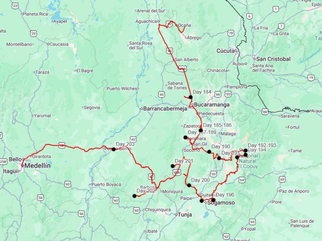
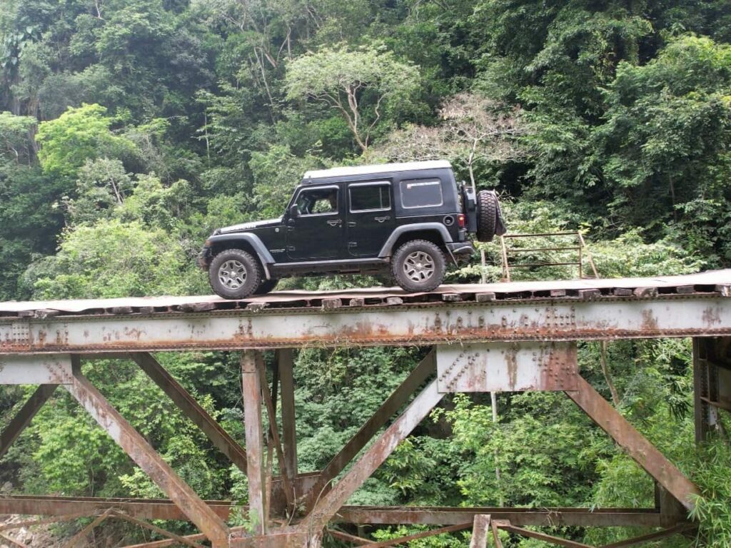
Dan and Patricia brought out their table and we had a great night playing cards. Patricia is part of a Euchre club back in California, and I’d always wanted to learn, so we played that until it was time to go to bed. Patricia and Delaney destroyed Dan and I without mercy. The next morning, we set out on a road I’d wanted to drive for years: The Via Ferrara, or Iron Road. It started only a mile away from our campground. It is more well known now since the Grand Tour trio, formerly of Top Gear, drove it during their Colombia Special in 2018, but I had known about it for a few years before that. It is called the Iron Road because it is an old railway route, abandoned since the 1990s. All the rails have been removed and repurposed, but the old bridges are still there, which is the main attraction.


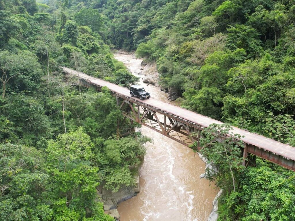
Dan and Patricia followed us down the narrow dirt track. Even though the locals still use it, it was pretty grown in, and we pushed aside some brush as we drove into the jungle. We soon came to the first bridge, which wasn’t anything crazy, other than the rusty metal deck that creaked and groaned as we drove over. We passed through two massively high tunnels that reminded us of Parque Natural Mexiquillo in Sinaloa, which we had driven through months before. We crossed one more metal bridge before driving along a section of ranchland, before getting to “the” bridge. This is the big one- and the most dangerous one. It sits maybe 150ft above the raging river below, is only as wide as a railroad tie, and has no guardrails. When the train tracks were pulled up, the old railroad ties were laid crossways across the structure of the bridge, providing a surface for vehicles to drive over. You can see though the gaps in the ties down to the river below!


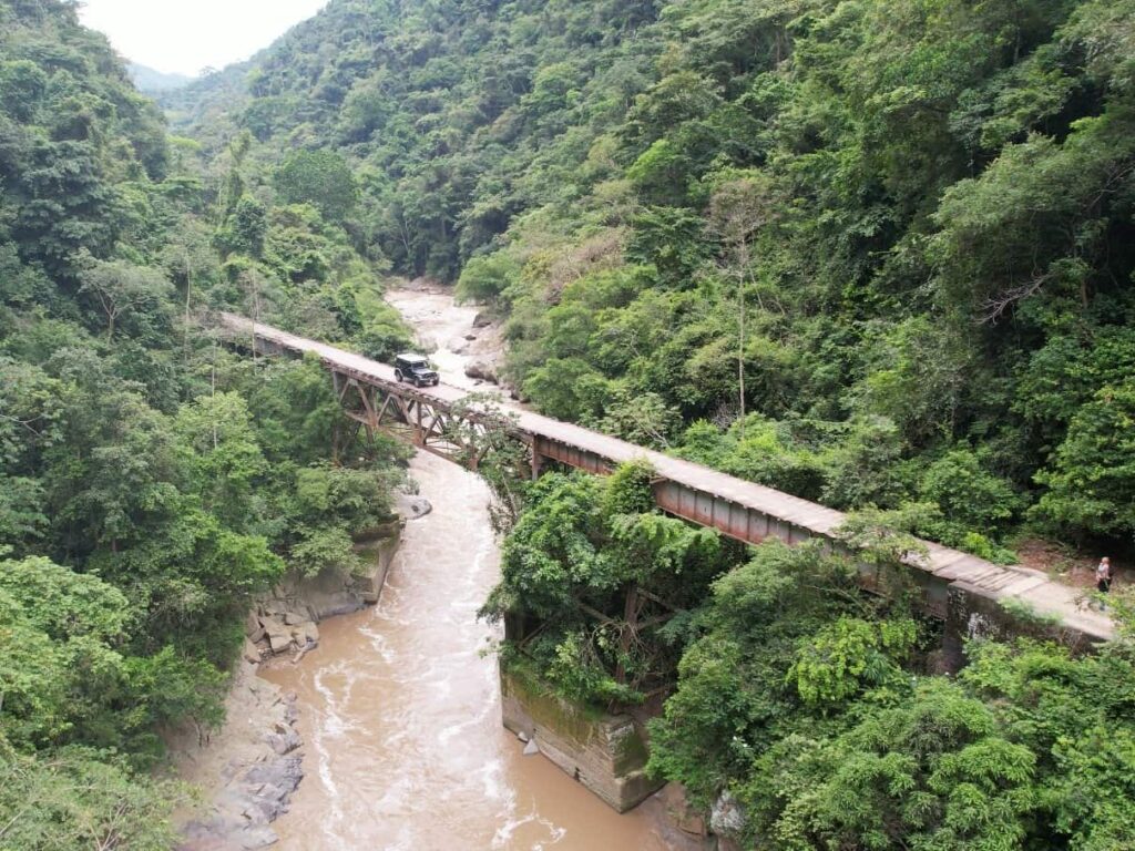
The Iron Road does go all the way through to the west side of the mountains, but a recent landslide has made it so that you have to do an out-and-back. I drove the jeep across, and Delaney drove it back. There were only a few inches on each side of the tires of railroad ties, so we had to be very careful to keep it straight. Dan drove their sprinter van both ways across, and I got some great drone videos and pictures.


After our fun with the dangerous bridge was over, we headed back out to the main highway, and continued south towards Bucaramanga. We took different routes to our destination on the south side of the city, with us going around and contending with tons of truck traffic, and Dan and Patricia going straight through and contending with hundreds of motorcycles that all zoom in and out of traffic. I’m not sure which one is more stressful to drive through! We met at a pizza place, hoping to get something better than what we’d had two nights ago. We were successful- the pizza was excellent.


Continuing on south of town, we contended with heavy truck traffic in both directions. We passed two toll booths, both of which had been taken over by locals protesting toll increases. This has been a fairly common sight in this area of Colombia- we’ve seen signs all over saying “Don’t pay the toll”, and passed through several other booths which were shut down, with people standing around it with signs. We didn’t feel threatened at all, and it was nice to not have to pay the toll- they are actually fairly expensive even by our standards, and must be prohibitively expensive for the locals.
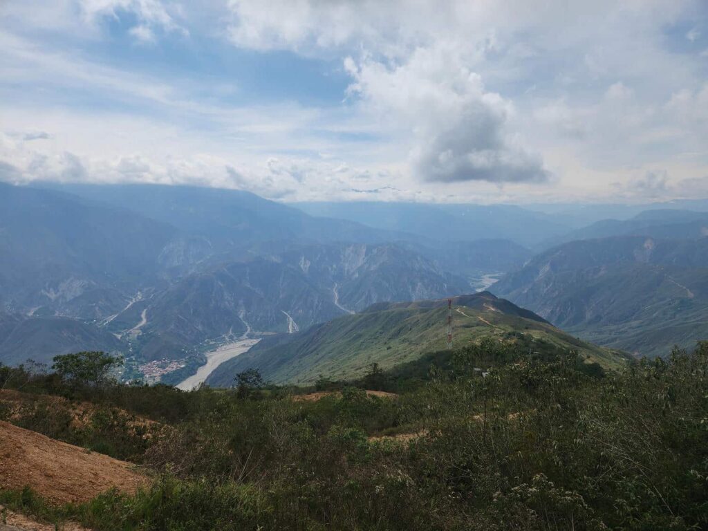
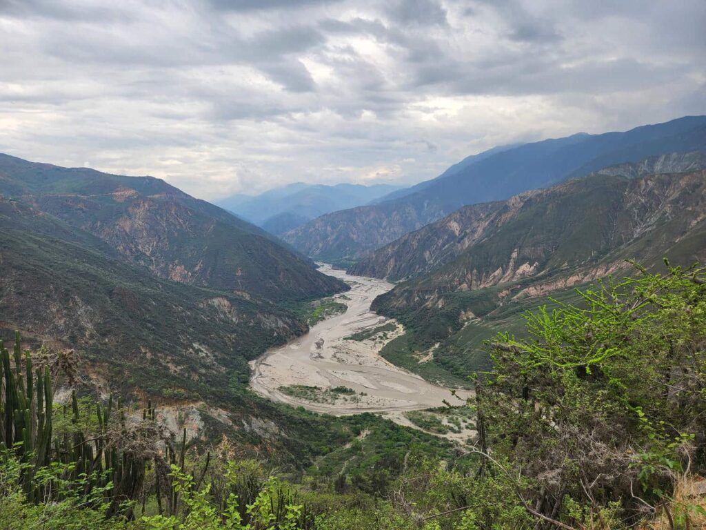
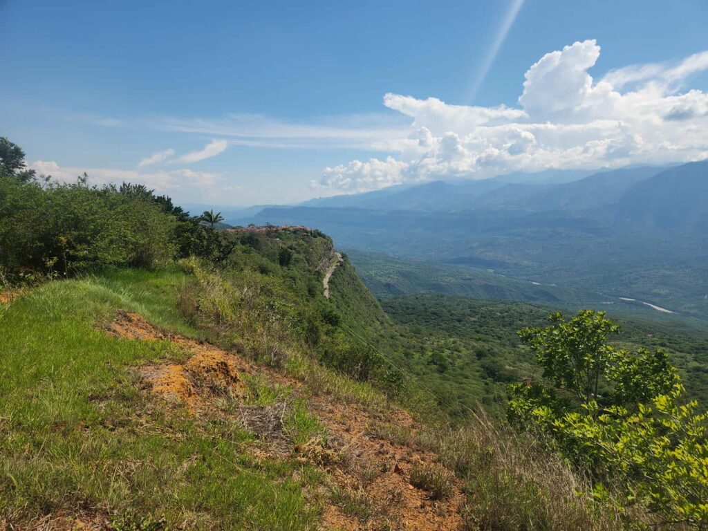
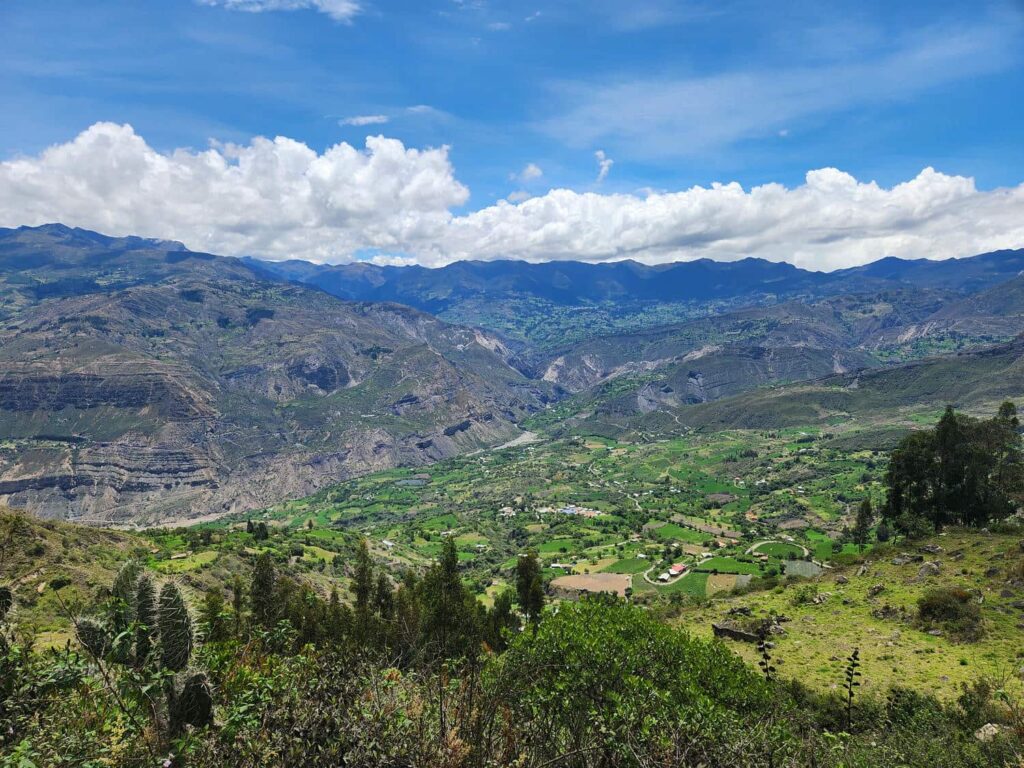
We descended rapidly from Bucaramanga, until we were at the bottom of an huge canyon- Chicamocha Canyon. It is one of the largest canyons in the world, and was stunningly beautiful. The river at the bottom reminded me a lot of Alaska- it was braided, stony, and full of sediment. We crossed the river and climbed up the other side, passing crawling truck after crawling truck. The views were absolutely ridiculous. We finally arrived at our spot for the night- a paragliding take-off point. In a bit of an embarrassing moment, Dan and I had both found the same spot, but each had contacted a different paragliding company to see if it was ok to camp there- they were right next to each other! It took us a bit to figure out what had happened, and had to pick one company or the other. We picked the one with a much better view over the valley, and had a great night. It had been a very long day and we were glad to be in a good camp spot, with a cool breeze and an amazing view. We were right on top of a ridge, with amazing views down into Chicamocha Canyon. Patricia made dinner for everyone, and the next morning Delaney made breakfast for everyone. It is so nice to travel with other people- the amount of work to make 4 portions of food is not that much more than to make 2 portions, and cleaning up afterwards isn’t that different either.

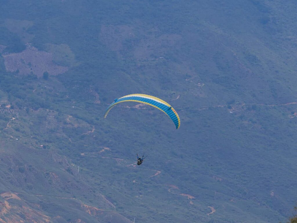
Delaney, Dan, and Patricia had all decided the previous night that they would go tandem paragliding (with an experience pilot). Our friends Craig and Summer, Alaskans that we had met in Guatemala, had said that this was one of the best places in the world to do it. I was too chicken, but the rest of the crew had an amazing time soaring high over the valley. It only turned out to be around $75 apiece- it is amazing how cheap things are in Colombia.

After around 3pm, the paragliding company headed home, and we had the mountaintop to ourselves for the rest of the day. I worked on photos and the blog, while Delaney worked on fixing a mesh screen on Dan and Patricia’s sprinter- her sewing skills come in handy quite often. We had another awesome night together, and finally got to teach Dan and Patricia our favorite card game- Nertz. It is basically competitive speed solitaire, and it requires a good solid table- their camp table wouldn’t have held up! The paragliding facilities had an awesome covered area, and we played cards late into the night.
After another wonderfully cool night, we headed down the road towards Cepita, a small village at the bottom of the canyon. The road had been closed for the last two years, but had opened up in the last two weeks or so. It was an incredible drive, with amazing views of the canyon as we wound our way down. We had lunch in the small village, which reminded me of La Playa- it had a similar colonial architecture, with whitewashed walls and colorful accents. We found a restaurant above the town square, and had an amazing meal for only 5 or 6 US dollars.


As we were on our way out of the restaurant, we met an older woman who spoke good English. She wanted to show us around the town a bit, and we followed her to where her and her Scottish husband were staying- her parent’s old property. They lived an extremely simple lifestyle, and were very proud of the little town. Apparently several Colombian movies have been filmed here. She also wanted to show us the mamon trees which grew all over her property- they produce a fruit that is quite delicious, but difficult to eat. It has a hard shell that must be half-peeled, before the fruit is squeezed out. The inner fruit has a very large pit, and the fruit itself is only maybe a quarter inch of pulp surrounding the pit. It tasted delicious, but was a very unique flavor that is difficult to describe. Perhaps a bit like a lime-flavored sweet tart candy? They claimed that the tree was extremely rare and “the 7th most exotic fruit in the world”, but it is apparently cultivated all over Central America and even in Florida, in hopes of a larger fruit-to-pit ratio.
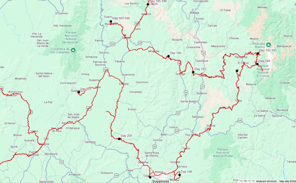
We headed back up the road to the main highway, and then drove south past the paragliding spot, continuing towards the town of San Gil. The dry landscapes of the canyon switched to a wet jungle almost in one curve of the road- it was astonishing how quickly the vegetation changed. We turned west at San Gil and made our way through the colonial town of Barichara and to Camping Guiamaro, a well-known overlanding campground run by a friendly Dutch couple who moved here 15 years ago. The campground was beautiful- the hosts are very interested in permaculture and growing everything they possibly can on the property- fruits, flowers, trees, bushes, you name it. After a tour from them, we settled in for the evening. We were quite lazy, and for the first night in almost a week, we didn’t play cards with Dan and Patricia and had an early bedtime.


We spent the next day doing mostly nothing. It had been a hectic few days with lots of long drives, and we were sure ready for a break. We did a bit of laundry, showered, and explored the property a bit. After lunch, another car arrived at the campground- what a surprise when it turned out to be Karin and Frank! They are Dutch, like the campground hosts, so we should have known that they’d be stopping by. That night, we played Nertz again, which is very stressful and fast-paced. As Karin and Frank watched, Frank, who has a very dry wit quipped, “this is ok for your heart?” We all about died laughing.
Our second morning at Camping Guiamaro, we got to dry some of their famous bread- sourdough. It was delicious, hot out of the oven with butter on it. After breakfast, the six of us walked the trail to the town of Barichara. We were expecting a mostly flat hike, but it went up and over a ridge instead of along the contours. After much longer than anticipated, we arrived in Barichara, perhaps the most well-known of Colombia’s whitewashed colonial towns. The town was perched on the edge of a cliff, and had ridiculous views over the valley below. The six of us had lunch together at a small restaurant, which was quite good, before wandering around the rest of town. Barichara is famous for its sandstone slabs, which are everywhere- all the streets are paved with them, they are inset into walls, used as walking paths, even the seats of an outdoor amphitheater were built out of them.


After exploring the town, Dan and Patricia took a tuktuk back to the campground, while Delaney, Frank, Karin, and I walked back. It was a hot day but we made good time back to the campground, where we enjoyed their unique outdoor showers- inset into the ground in a garden, with solar-heated water. They are probably the most beautiful showers I’ve ever seen.


After one final night of cards, we headed out in the morning. Today was to be another long drive day- it seems we just can’t get away from them. Colombia is a large country, about the size of California and Texas combined, but the roads are usually in poor condition. It takes forever to get anywhere sometimes! We drove through San Gil, filling up on fuel, water, and food. It is definitely a good feeling to be full of those three things!
We headed to Hoyo de los Pajeros, or “hole of the birds”. It is a sinkhole, similar to the others we have seen with swallows or parrots living inside, but the bird that lives in this sinkhole is special- the Oilbird. It is quite unique: the only nocturnal fruit-eating flying bird in the world. Their eyes are also uniquely adapted to living in caves and foraging at night, as their eyes have the highest light-gathering ability of any bird. I thought that I would have to wait for darkness when the birds fly out of the sinkhole to start foraging, but when I peered over the edge, there was one perched right on an exposed cliff down in the sinkhole. I had just snapped a few pictures when all of a sudden, the sky opened and the rain came pouring down. Delaney and I beat a hasty retreat to the jeep, making it inside before the real brunt of the rain came down. We couldn’t believe how hard it was raining.
Since we’d already found the Oilbird, and because the area wasn’t an ideal campsite, we decided to drive on. Dan and Patricia had stopped at a paid campground not far away, but we preferred to continue on further. We drove through the rain on some slippery back roads, before finding some better roads through some sugarcane plantations and processing facilities as the rain finally let up. We passed through the city of Mogotes, and the road deteriorated again as we went up into the mountains. Just before the sun set, we found a spectacular pullout near the top of a pass with amazing view. It was a fantastic campsite.


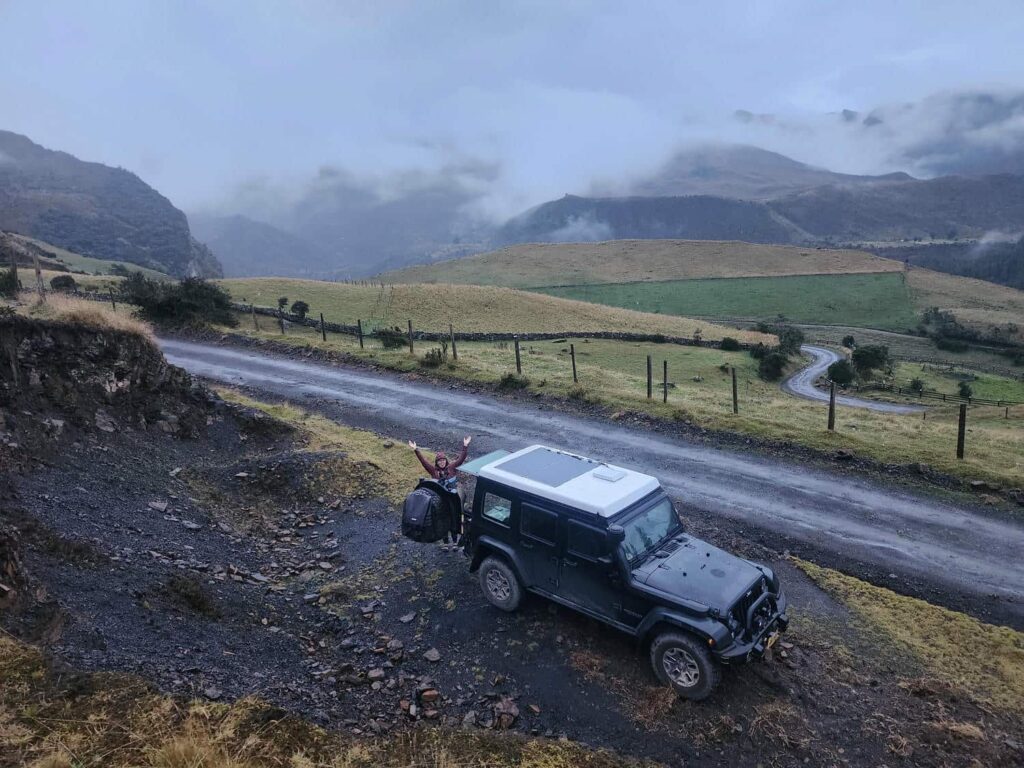
We weren’t in too much of a hurry to leave the amazing view the next morning, so we took our time. The sunrise was amazing, and there were lots of birds around. Dan and Patricia caught up to us around 10am, and we enjoyed the view together for a bit. We then helped them air down their tires- they hadn’t done this for the entire trip! The road we were on was pretty rough, and they said that going from the ~70psi they were at down to ~35psi made a world of difference. We continued on this rough dirt road all day, up and down through the eastern Andes. Other than some small cattle ranches here and there, the terrain was all jungle. It was a fantastic day of driving. We camped on a small pulloff at another mountain pass, and mostly stayed in our vehicles as the rain returned with a vengeance. It rained all night long. The next morning, we parted ways again and trundled down the road into the town of Soata, returning to pavement for the first time in a few days. We stopped at a hummingbird feeder that is known for attracting the rare Chestnut-Bellied Hummingbird, which is only found in a very small area in this region of Colombia. There were nearly a hundred hummingbirds zooming around the feeders, with quite a few Chestnut-Bellied. We were all alone there, and spent nearly an hour watching them.


We continued on up further into the mountains. The road was nicely paved for a few miles out of Soata, but quickly deteriorated to a small dirt road. The road turned and twisted as it climbed and descended across the maze-like network of ridges and valleys. We stopped in the town of San Mateo, which is famous for its unique honey. The bees in the area somehow make it from tree sap rather than from flowers, which gives the honey a very intense flavor- kind of like molasses or maple syrup, but quite indescribable. We bought a jar from a very friendly lady at one of the honey shops in town.


We continued on the squiggly roads, passing a few small towns that were just perched on the side of massive valleys. Some towns were right across from others, perhaps only a few miles as the crow flies, but it would take nearly an hour to drive between them due to having to drop all the way to the bottom of the valley and drive back up. We joked about the crazy soccer rivalries the towns must have- every single town, no matter how small, had a very nice soccer pitch.
We finally reached our campsite, a small pullout on the side of a very small dirt road. It had an amazing view of the valley, but it was quite cloudy and foggy. I wandered around a little bit as Delaney started dinner, but the fog turned to mist and we retreated to inside the jeep to eat dinner. The next morning, we were greeted by some very young and small border collies. They had initially been herding some sheep in the field below us, but must have smelled our breakfast. They were very friendly, but also quite interested in our food. We felt bad that we’d distracted them from their work, but we couldn’t get them to leave and go back down to the rancher below.


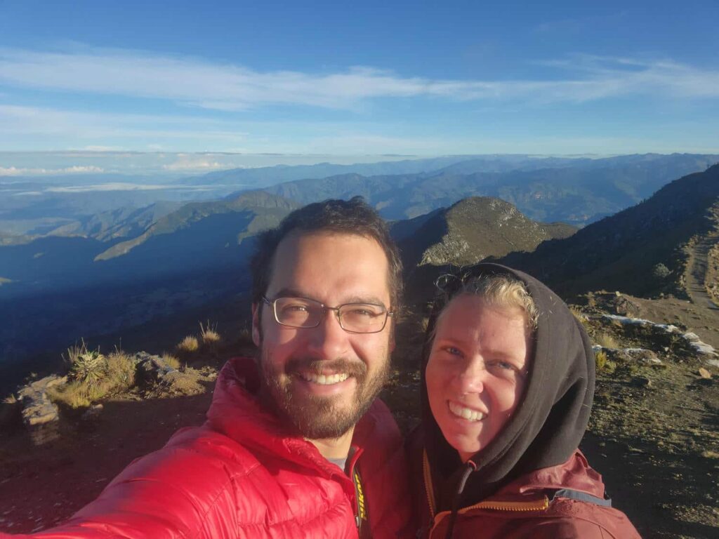
We geared up for a hike as the collies sniffed around for any possible dropped morsel, and then set off down the road towards a small trailhead. The dogs eventually left us, and we started into the trailhead. The trail first led right by someone’s house, and they were very friendly and pointed the way to the lake, which was our destination. We dropped down into a small valley past a bunch of cows, and then climbed up the far side before reaching the lake, which was hanging right on the edge of the valley. It was beautiful- far above treeline, with awesome views of waterfalls and the El Cucoy mountains through the fog. We stayed up there for 2 hours or so, wandering around and marveling at the scenery. The weather had broken briefly to give us some good views, but we could tell that it was closing in again, so we hurried back to the jeep. We got there just as it started raining, so we quickly cooked some macaroni and cheese and retreated into the jeep for the rest of the day. We were so glad that we can stand up inside! We had a lazy afternoon while the rain poured outside.


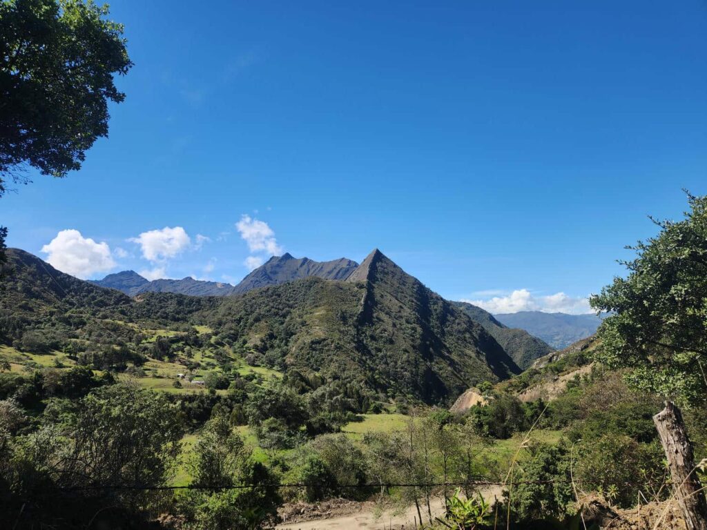
The next morning, we drove up the road a bit further to another trailhead. This was one of the “official” El Cocuy National Park trailheads. To hike within the park, you are required to have a guide, which are quite expensive- at minimum, around $75 USD, but probably closer to 100$ by the time you include mandatory insurance, transportation, fees, etc. This is extremely expensive for this part of the world, and we really weren’t interested in doing this. Fortunately, none of the trailheads for the park are at the actual park boundary- the boundary is always a few miles in. So, it was perfectly legal for us to hike without a guide up to the actual border, which we did. The hike started at well above treeline, close to 13,000ft, and ran up the valley. It was beautiful- there were all sorts of frailejone plants, or “big monks”. They are unique to this area of the Andes, in particular the Páramo, or what we would call alpine tundra. They are quite a unique plant, and we later learned that they play a huge part in forming the environment- their trunks are hollow, and they hold onto huge amounts of water, and release it during dry season, allowing other more sensitive plants to survive.

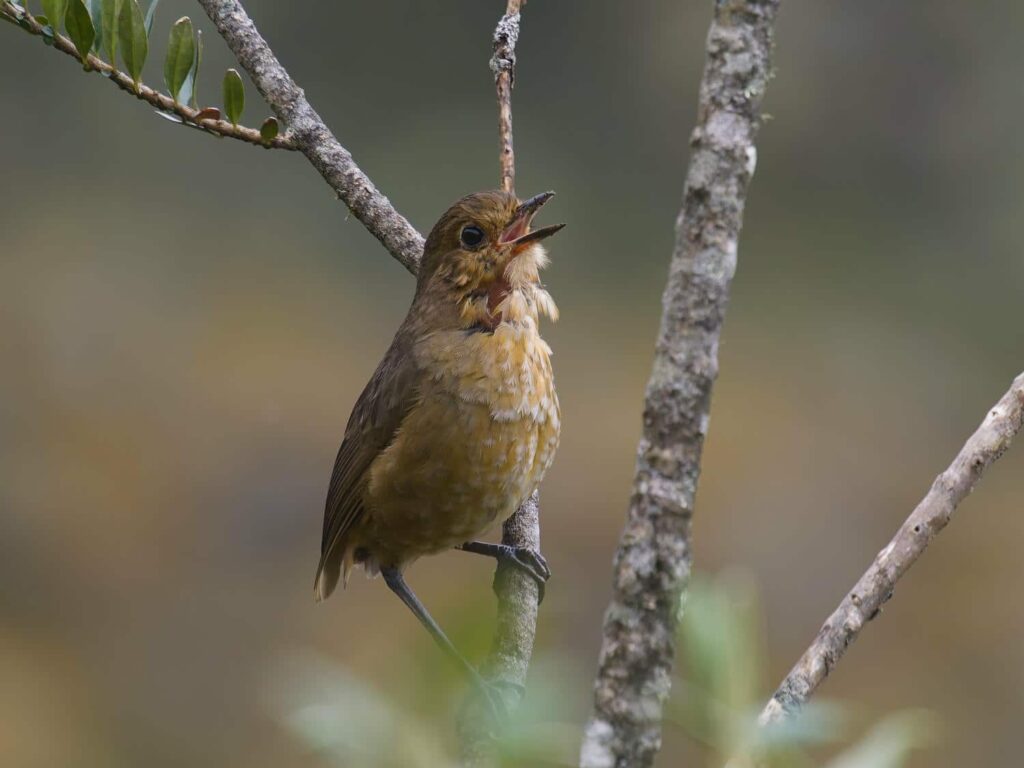
We found a lot of birds that are endemic to the high-altitudes parts of the northern Andes, including the Green-Bearded Helmetcrest, a unique hummingbird that feeds on the flowers of the frailejones. We turned around at the park boundary and headed back to the jeep. We were pretty hungry when we returned, and planned on going back to our previous campsite to make lunch. We first had to turn the jeep around on the tiny little road we were on, so we drove a few hundred yards up to a small pulloff.


While turning around in the pulloff, the front of the jeep suddenly dropped into the mud. What had looked like a very solid surface was in fact nearly quicksand- glacial silt from above had been carried by rainwater into the pulloff, which had been dug well below the level of the road surface. This had made a bottomless pit of mud that we were now stuck in! We tried to dig under the rear tires and put larger rocks underneath, but we just sank further. Every time we tried to back up the jeep sunk in deeper!
We were in quite a pickle- there really wasn’t a whole lot to winch to, the road was very small and seldom-traveled, and the fine mist of the morning had grown into a rainstorm. After an hour or two of digging, I walked down to a small farm we’d seen while driving up. There were two men planting onions, and though there was a strong language barrier, I showed them a picture of the stuck jeep and pointed up the hill. They indicated that they’d finish what they were doing and come take a look. I went back up the hill, and 20 minutes later they showed up in an ancient tiny sedan- think 1985 Toyota Corolla, but smaller. And it wasn’t just them, but the wife of one of them and three kids!
They tried pulling us out backwards with their little sedan, which did absolutely nothing. We were pretty sunk in at this point! They tried using an old come-a-long that they had, but it wasn’t strong enough to move the jeep. At this point, I figured that they only way out was forward, which I wasn’t looking forward to- the front of the jeep was submerged, and we were now up against an underwater ledge that was about three feet tall. The winch was completely underwater, but I was able to get it unspooled and connected. With the farming family’s help, we ran the winch line up to the top of the cliff above the pullout, securing it to a small fence post which we quickly pulled out, then a small tree. We were able to move a little bit by winching towards the tree, but when the jeep hit the underwater ledge progress stopped and we ended up pulling the tree out. One of the men had a great idea, and again secured the winch line to the fence post, then secured the top of the fence post to a tree, anchoring it more firmly. This worked, and Delaney and I could have about cried with joy when the front of the jeep popped up out of the puddle, fully supported by the winch line.

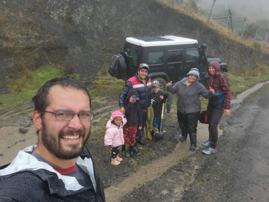
The family then worked for almost half an hour, nearly filling the entire mudhole with gravel, so that the back tires wouldn’t get hung up on the ledge. I couldn’t believe how enthusiastic they were about digging- it had been absolutely pouring rain this entire time, and they were knee-deep in freezing water! I then drove across the new “road” that they had built, and we were finally free. Incredibly, the family wouldn’t take the money I offered them for their help- I had to physically put it in their car. They had helped us for over two hours, in freezing rain, almost insisting on doing much of the digging. They even invited us back to their farmhouse to have some coffee and to dry off. In hindsight I wish we had accepted, but we really just wanted to get out of there at this point, having been stuck for almost four hours. We were absolutely soaked, and so was the inside of the jeep. We bid them farewell, and headed off down the road. We stopped a few miles later to change into some dry clothes and to decompress a bit. For the rest of our time in the El Cucoy area, we were totally gun-shy about any pullouts. This one had looked completely innocuous, and we would have done the same thing and gotten stuck 99 times out of 100.
After we were again warm and dry, we decided to keep going with our plan for the day- drive to another trailhead and hike there the following day. It was a short drive on small and rough roads, through fog that would occasionally part to give us spectacular views. We parked at a ranger station, and I went in to chat with the rangers and to see if we could camp there. The rangers were super friendly, and even though none of them spoke any English, I think that they were the best at communicating with simple Spanish than anyone else we’ve met so far. I’m not sure if it’s just me, but I’ve found that most people in Latin America seem to have very little experience talking with someone who doesn’t speak Spanish, or speaks very little. I know that when I’m talking with people who may only speak a bit of English that I naturally use simpler words and phrases, and I avoid figures of speech like the plague (ha!). Most Latin Americans seem to not do this- I’m reminded of a rancher we met in Baja California who kept repeating the same word, louder and louder, as if that would help me understand him. Anyhow, the rangers were very welcoming and fascinated by the fact that we were from Alaska. They told us that we were more than welcome to stay the night.
Soon after I finished talking to the rangers, it started pouring rain again, so Delaney and I retreated to the jeep for the rest of the evening, only coming out to cook a quick dinner. The next morning, the sky had cleared up, and we had some incredible views from a small overlook nearby. We then drove another few miles down to the trailhead for one of the most popular hikes in El Cucoy- the trail to Púlpito del Diablo, or the Devil’s Pulpit. Like the hike we’d done the day before, the full hike requires a guide, park entrance fee, insurance, etc. We instead hiked to the first of several lakes along the trail, which is still outside of the park boundary. It was only about 5 miles roundtrip, but it was stunningly beautiful. The glacier-carved valley reminded us of home, as did the mist and fog. We were quite surprised to see a few deer along the way- we’ve seen very few animals larger than a squirrel on the whole trip, so seeing deer was a treat!
When we returned to the trailhead, we had lunch at the tiny restaurant there. It was shaped like an octagon, only around 30 feet in diameter, with half of that being the kitchen. There were two large well-worn tables inside, made of rough-cut lumber and then lacquered. It was a very rustic place, but beautiful. There is only one option for lunch, which was amazing- potato soup, rice, spaghetti, tomato, fried plantain (like bananas), potato wedges, and a meat that we aren’t 100% positive on. It didn’t taste like beef, pork, or chicken, but there were quite a few sheep in the El Cucoy area- so we’re guessing it was mutton! After a cold and wet hike, it was fantastic, one of our favorite meals of Colombia so far. The atmosphere was amazing- it was pouring rain outside, we had one of the tables to ourselves, and there were a few grizzled ranchers and the friendly cook eating at the other table. Though I dislike the term, it felt like a truly “authentic” Colombian meal.


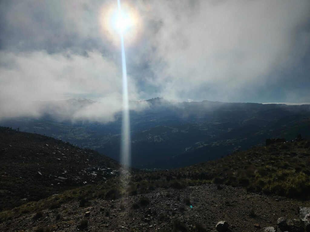
After lunch, we drove on into the rain through the town of El Cucoy, a colonial mountain town perched on the hillside. It is the largest town in the area and is the jumping-off point for tourism in the park, even though it is an 12-hour bus ride from Bogota, the nearest airport. We drove on to Cerro Mahoma, a place that Tim had heard of from another traveler. We had descended back below treeline after leaving the trailhead, but were back up among the frailejons and above treeline not long after passing through town. We were all alone after turning off onto the Cerro Mahoma road, which is little more than a two-track which accesses some communication towers at the top. We had our pick of the pullouts, and after our experience the previous afternoon, we were very careful in selecting which one to camp in! The fog was thick the whole afternoon, and the wind had picked up a bit, so we chose the pullout with the most shelter rather than the one with the best view. We fell asleep quite quickly after a very long two days.

We woke the next morning to a gloriously clear day, but it was frosty out! We had a view of the entire El Cucoy mountains, with glaciers, cirques, and mountaintops. The Devil’s Pulpit was quite prominent- it is a very large and very square mountaintop that was silhouetted on the horizon. We drove all the way to the top and were speechless at the 360° view. We could see snow-covered mountains to our east and thick jungle to our west. We haven’t used our drone a whole lot so far, but we definitely did here!

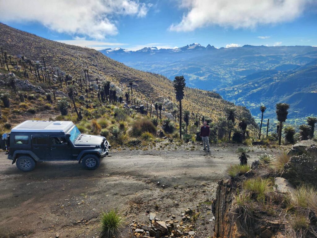
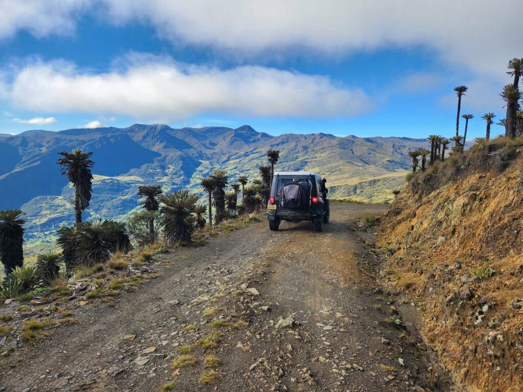
We’d noticed a pattern over the 4 days we’d been in the area- it was clear in the morning, but fog inevitably came in by noon or so. We had a long drive day ahead of us that we’d heard had some stunning views, so we left Cerro Mahoma earlier than we normally would have liked so that we could enjoy the views and beat the fog. We drove south through the mountains all day, with some of the most amazing views I think I’ve ever seen. All of it was on a tiny dirt road through the mountains, much of it above 12,000ft, and we hardly saw any other vehicles for the first few hours. We zig-zagged up and down through the mountains, passing a few tiny colonial villages, all with the now-familiar whitewashed walls. We then passed through a coal-mining area, with lots of small mines, instead of the massive open-pit mines that are more common in the U.S.
We finally ended up on another mountain with communication towers, near the town of Mongui. Getting there was a bit interesting- the trail to the mountaintop was quite wet and slippery, and sloped downhill quite a bit. We were able to go super slow and avoid any sliding, and made it to the grassy mountaintop. It was a fantastic camp spot, with a beautiful view of the surrounding area. We normally would have spent two nights in such a cool spot, but we were due to meet Dan and Patricia again outside of Sogamoso, the largest town in the region. They had rented an AirBNB for a few nights, and invited us to join them! We drove over through the north side of Sogamoso, glad we didn’t have to go into the city- it seemed a bit dirty and rough. We later learned that it is reasonably safe, just a bit rough around the edges, with its main industries being steel and coal.


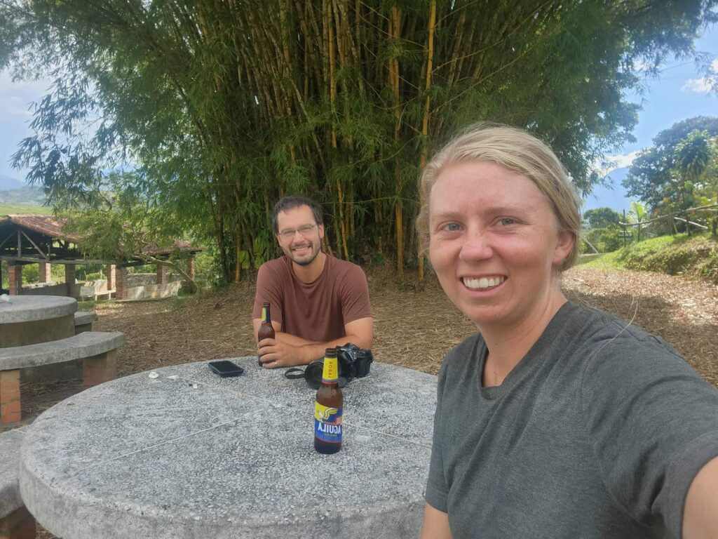
We met Dan and Patricia in the town of Tibasosa, just a few miles outside of Sogamoso. The town had a beautiful central square, with lots of shops and restaurants, as well as the ubiquitous giant church. With my and Dan’s love of pizza, we’d scoped out a pizza place that looked really good- the owner was Italian! It was fantastic, and Dan and I were finally able to put the terrible pizza we’d had in La Playa about two weeks earlier earlier behind us. We then drove up to the place they’d rented- it was huge, with massive floor-to-ceiling windows looking out over the valley. The caretaker of the place was extremely friendly and helpful, and perhaps too helpful- it was hard to get rid of her sometimes! She insisted on showing us every corner of the place, including where the light switches were, where the plates were, where we should put our shoes, etc. She meant well, but it was late in the evening by the time she went back to her place. Our bedtime was briefly interrupted when Patricia found a tiny scorpion in their bathroom. After sweeping it into a dust pan and chucking it outside, we enjoyed our first night in a real bed since Cartagena, and slept in a little bit, which is rare for us.
We spent the next 3 nights there with Dan and Patricia. We played lots of cards, played with Brodie, made some amazing food, and took advantage of the washing machine. One of the days, we drove to Nobsa, a town north of Sogamoso known for its wool products. Dan and Patricia had already been there, and bought a ruana– essentially a wool poncho. All the locals in El Cucoy had been wearing them, as well as many other people we’d seen around. They were happy to go back, and I bought one as well. It is very warm and comfortable, and it will sure be nice when we are in high-elevation Peru and Bolivia! There are very similar articles of clothing there, but they are made out of Alpaca fur instead of wool- Delaney plans on getting one of the Alpaca ones!


While staying with Dan and Patricia, the caretaker also introduced us to tinto, which is coffee mixed with minimally-refined sugarcane- essentially solid molasses. It is popular all over Colombia! It was delicious, and we had many pots of it as we played cards into the night. The caretaker and her daughter also made dinner for us one night, after a shopping trip with them in Tibasosa. It was essentially a soup or stew, made with potatos, corn, onions, and beef. It was not my favorite meal, but was quite interesting.
After three wonderful days together, we had to go our separate ways once more. Dan and Patricia had gone to El Cucoy around the same time we had, but only spent two nights there. They had then gone to Bogota to pick up a large Amazon shipment to replace the items that had been stolen from them during shipping from Panama to Colombia. They also had a veterinarian look at Brodie’s eye, which had been having problems since shortly after Palomino on the northern coast. It turns out he had a pretty bad scratch on his eyeball, which will take some time to heal. Delaney and I had to begin heading west towards Medellin, as Delaney had to fly back to the States for her best friend’s wedding.
From Tibasosa, we drove north on a small road through Páramo de la Rusia, which had been recommended to us by Karin and Frank. The landscape was quite similar to the area around El Cucoy, with frailejon plants everywhere! The road quickly deteriorated as we descended down the other side of the mountain. We found a small pullout along the road, and had a peaceful night there. Some locals stopped by at dusk to see what we were doing, and were happy to see that we were OK and just spending the night. It was a bit startling to hear the knock on the side of the jeep!
The next morning, I walked up the road a bit looking for birds, before driving down to the bottom of the valley. It was a beautiful area, with cattle ranching in the valley bottom and thick, impenetrable jungle on the slopes. As we drove further, we passed through a Taoist community, which was very friendly but looked drastically different than the colonial villages we had been passing through. Further down the road, we tried to take a short cut that was shown on Google Maps west to Highway 45A, but after around 10 miles it petered out into the mud amidst some cattle ranches. It was disappointing to have come so far and then get turned around, but we weren’t really in the mood to argue with mud after getting stuck a few days earlier. Back on the other road, we were then stopped for nearly an hour for road construction. It was a bit of a frustrating afternoon, but we eventually made it to the main highway and then to our destination for the evening, the village of Guadelupe. We camped outside town at Balneario la Gloria, which roughly translates to “Glory Pool”. It was a beautiful waterfall and with a swimming hole below, but the swimming hole was mostly empty. Delaney and I enjoyed a few beers from the nearby shop after a very long day of driving, before cooking dinner and going to bed.

That evening, there was a torrential rainstorm. We were warm and dry inside the jeep, and we woke to an amazing sight- the swimming hole, which had been completely empty, was now completely full of muddy water. It was probably now 10 feet deep! The waterfall was now a raging torrent. My sandals, which I always leave outside the jeep on the ground, had been washed about 20 feet downhill by the rain- it’s a miracle I didn’t lose them!
We drove down towards Guadelupe, turning before we reached the town. We drove down a tiny ranch road, and parked where we couldn’t go any further. We walked down a beautiful stone path, which must have taken ages to build, towards our destination for the day: Las Gachas, which translates to “the porridge”. It is a geological oddity: dozens of giant “potholes” in a river bottom. The river bottom is solid stone, but pockmarked with potholes, all about six feet across, which seem nearly bottomless. It is a popular spot to cool off- I’m sure that on hot days each pothole has at least one person in it cooling down! We wandered up to the top of the solid rock river bottom, and then down to a waterfall at the bottom. I love geological oddities of all sorts, and this one was a doozy!


On the walk back to the jeep, we noticed all sorts of army ants on the path that hadn’t been there when we were on our way in. The difference between the workers and the warrior ants was striking- the warriors were huge! I got a few on my shoes, and they dug their pincers in and wouldn’t let go. I had to basically rip their heads off to get them off. Delaney was in sandals and thankfully didn’t get bitten! When we got back to the turnoff from the road to Guadelupe, there were two giant tour busses of Colombian tourists just starting in on the walk to the river. We were so glad that we’d beat the crowds!
As we drove out back to the main highway, we crossed a bridge over a raging river- no doubt the result of all the rain the previous night. It was just about to overflow its banks, and on the drive south on the main highway, several rivers had overflowed. Apparently it usually isn’t quite rainy season yet, but it had come early this year. We drove south on 45A, which was in quite good condition, until we turned off at the town of Puente Nacional. Here the road was much worse, and we drove on and on through small farms and ranches. The vegetation was incredibly thick and green. We are so thankful that our jeep is so comfortable on rough roads, especially when the tires are aired down. It would have been miserable at full highway pressure!
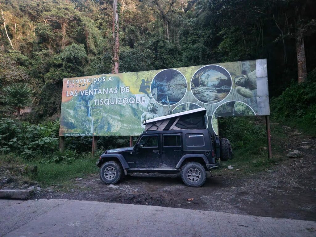
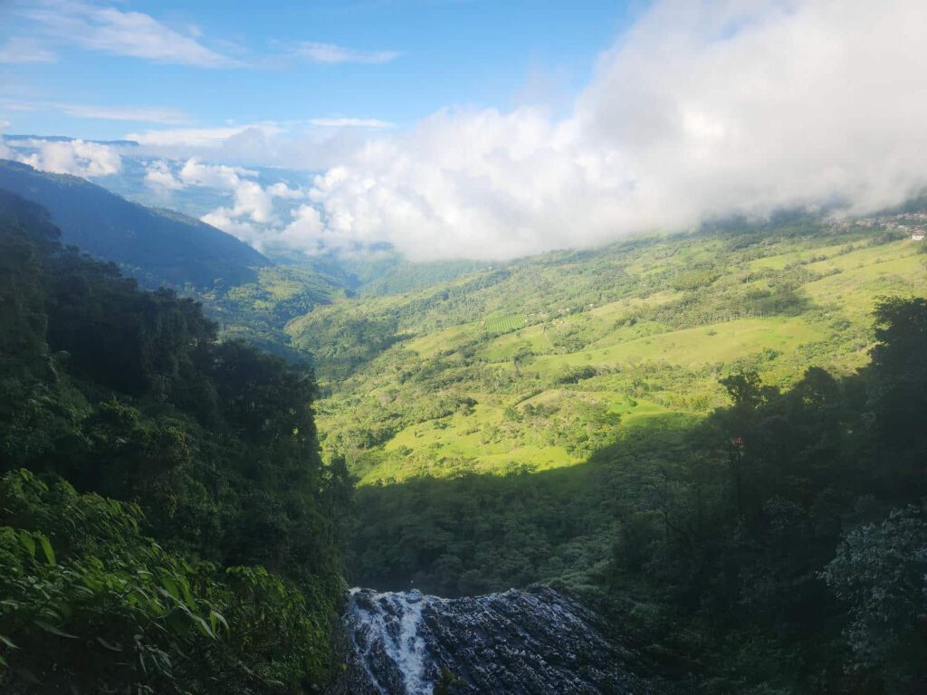
We eventually arrived to the village of Florián. We didn’t quite go all the way in, but turned off the road down a very steep hill. We would definitely need our low-range gears to get back out! On the way down, we got our first views of Tisquizoque- a giant three-stepped waterfall. The water pours out of a cave in the side of a cliff, and then falls a total of around 1000ft to the valley bottom. With all the rain the previous night, the waterfall was in full flow- a muddy torrent pouring out of the side of the mountain. We drove down the very steep road to a small farm, which owned all the land at the base of the waterfall. They charge 7000 COP, about $2USD, to hike down the trail to the waterfall- quite cheap, even by Colombian standards. We hiked down the very steep and slippery trail through the jungle, where we popped out of the forest into a heavily eroded gorge at the bottom of the waterfall. We could only see the bottom two cascades, but the size of the waterfall was mind-blowing. We were nearly 100 yards away from where the water crashed to the ground, but we were still getting tons of water spray! Apparently you can normally access a pool at the base of the waterfall to swim, but there had been a small landslide which had taken the trail out.


We hiked back up the trail, stopping at a small viewpoint, before getting back to the jeep. We flew the drone around the waterfall for a bit- too spectacular of a location not to! We then drove back up the super steep trail to the main road. It was one of the steeper roads we’ve driven so far, and we definitely needed all the offroad capability the jeep had. We drove back up the hill and parked next to a billboard advertising the waterfall and the town of Florien. There were a bunch of motorcycles parked there, as it was really the only spot to park on the road to visit the “cave” side of the waterfall. There we met Johan, a young teenager from Bucaramanga. He was quite earnest and knew a little bit of English. He was a tour guide of sorts, staying with his mother in Florien. We taught each other some words from the other’s language, and shared our dinner with him. He was quite earnest and I think he found it fascinating to talk with foreigners.

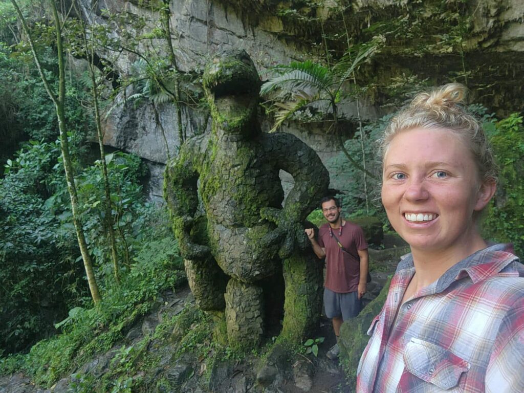
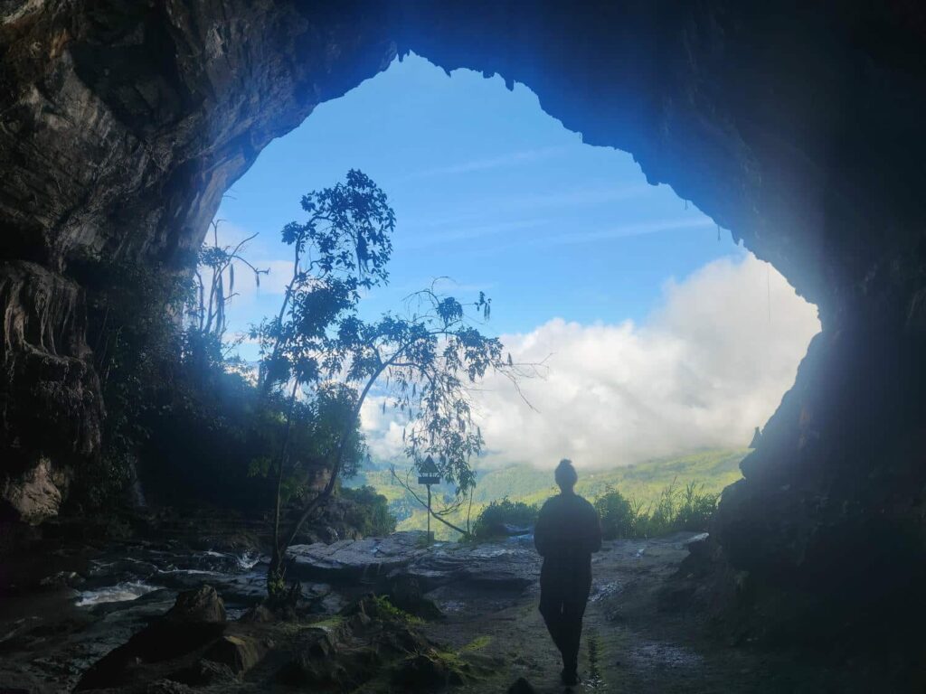
We talked with Johan until dusk and then headed to bed. We were just parked on the side of the road, the main access point to Florien, but the night was thankfully very quiet. In the morning we made breakfast and then headed down to explore the upstream side of the waterfall. We started down the steep trail to where the river enters a large cave. The river is in the cave for a few hundred yards until it exits out of the cliff face we’d seen the day before. Right before we entered the cave though, there is a famous stone T-Rex statue- it is quite impressive, over 10 feet tall! We then descended down into the cave, which is complete with all sorts of stalagmites and stalactites. The trail through the cave included a sketchy cable-stayed footbridge, with a lot of the planks either broken or missing!


We then made it to where the river exits the cave in spectacular fashion, crashing down with the first of the 3 waterfall steps. We had an incredible view from the hole in the cliff- the village of Florien, the valley, and all the coffee farms and banana plantations surrounding the town. Tisquizoque is easily the most impressive and beautiful waterfall we’ve ever seen!

We tried to drive south of Florien down to highway 60, and we made it quite a few miles down a very steep and winding road, but a friendly local told us that the road shrinks down to where it is only passable by motorcycles. We were a bit disappointed, and we had a difficult decision to make- keep trying to make it down to highway 60 on a longer route, or backtrack many hours through rough roads to highway 62. Highway 60 was known to be rough and slow, with possible landslides, and highway 62 was reported to have some major delays for landslide repair, but it was a major highway other than that. Compounding this, we really needed to be in Medellin the following afternoon so we wouldn’t miss Delaney’s flight the morning after that!
We eventually chose the northern route, highway 62. It was a major highway, and even though there was some construction that had a reported 4-hour delay, we were much more confident that it would get us through to Medellin within our timeline. It’s been so nice not having deadlines on this trip, and it stressed us out a surprising among to have the deadline of Delaney’s flight. Our only other deadlines on the entire trip have been meeting Brooke and Kevin in Guatemala, and shipping from Panama to Colombia! In the end, we absolutely made the right decision. We arrived at the construction zone right as they were letting people through. It was also a Sunday, so not much construction work was happening. All the construction was to repair an absolutely massive landslide- it seemed as if the entire valley had all let loose at the same time and flowed downhill a few hundred feet, keeping the surface mostly intact. They were completely rerouting nearly 2 miles of highway to avoid the landslide area.
For the next few hours, we zig-zagged down a reasonably good highway, with stunning views all the way as we descended from around 9000ft to only 300ft at the Magdelena River Valley. We’d scoped the area out for camping, but nothing looked too promising, as seems to be usual in the more low-lying areas. The lowlands are usually much more agricultural, with every square inch of ground used and fenced off. We’ve also noticed that the lower areas feel a bit less safe, dirtier, and poorer. We’re not entirely sure why this is, but we’ve noticed it in almost every country so far. With few options, we stayed at a gas station truck stop, which turned out to be much nicer than we thought it would. It was reasonably quiet and bug-free, which was awesome. They also had restrooms and an outdoor sink where we could do our dishes, which is always nice! As an added plus, I heard what sounded like a giant parakeet calling, and eventually found a Blue-and-Yellow Macaw in the trees right behind the jeep. It was definitely one of the birds I’d wanted to see the most in South America, and here it was at a gas station!


We were woken up by all the truck drivers leaving in the morning- they unfortunately let their engines idle for almost half an hour before actually leaving! All we had to do today was drive up to Medellin. We’d reserved an AirBNB for the 5 nights Delaney was going to be gone, plus the night before she left, plus 2 nights after she returned. We drove from the gas station across the Magdelena River, which rivaled the Mississippi in size, and then started up the hill towards Medellin. We’d expected that the road would be about the same as where we’d come from, but it turned out to be in fantastic shape- turning into a full four-lane interstate-quality highway. We arrived in Medellin a few hours earlier than we had expected, and battled the ferocious traffic to get to our AirBNB. The roads near it were incredibly steep and tight city streets, but we eventually made it. It was in a safe location- a rare dead-end road that we felt quite safe parking in. We definitely don’t love street parking, but it was an awesome spot here! We moved our things inside, and Delaney prepared to leave for Denver in the morning, while I settled into the place I would be staying alone for the next 5 nights.