After leaving Boulder on November 5th, 2025, Delaney and I headed up the familiar Highway 36 from Lyons to Estes Park. Our first stop, much like our stop in Northglenn that morning, was at my grandparent’s old house- the other grandparents! They had retired here, and all my childhood memories of them were at this house. It had been our base camp for all the many hikes & climbs I had done in Rocky Mountain National Park. As with my other grandparent’s house, I hadn’t been back since it had been sold and it looked remarkably unchanged. The upstairs is an AirBNB now, and from the pictures the interior is similarly unchanged- down to the original 1970s vintage stove and oven! If it ain’t broke, don’t fix it, I guess, though the reviews for the place somewhat wryly comment on the “rustic” and “vintage” feel.
After reminiscing, we drove up Fall River Road, to Estes Valley Memorial Gardens, where my grandparents are buried. After some time, we found their headstone, where my grandmother had been buried some 20 days earlier, next to my grandfather. It is a beautiful spot, with an amazing view up at McGregor Mountain across the valley. I think most of my mom’s family will be buried here eventually- good to have everyone in the same place, I suppose!
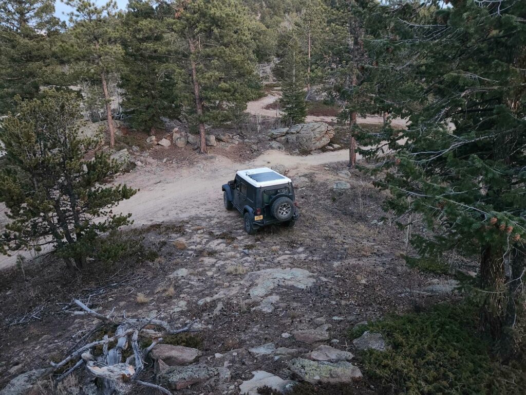
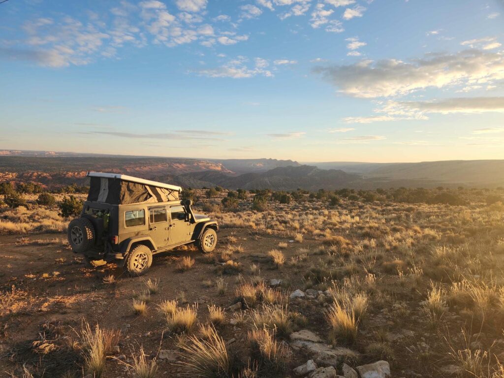
We went back to town and walked around the downtown shops and riverwalk. I hadn’t been here in the “offseason” before, and it was strange to see so many shops closed up for the season. It is a busy, busy place in the summer! We got some food for the evening and for our hike the next day, and found an amazing campsite up Pole Hill, a rough jeep trail I had been on years before in my Cherokee. This was our first offroad test for the jeep, and it performed much better than I thought it would. My jeep TJ, our offroad jeep back home, has a very rough ride unless the tires are aired down to 6 or 8 psi. This jeep, with full highway pressure, rode like a cadillac up the rocky trail. I was shocked!
We had a bit of a fitful night- it was very windy, and we were camped at over 8,000ft, so it was a bit chilly! We woke up early the next morning and trundled back down the trail to the highway, hoping to have a spot at the Glacier Gorge parking lot for our hike that day. The lot fills up very quickly in the summer, sometimes being full by 5am, with the next parking lot a half mile away. We met my cousin Katie there at 6:45am, and we were the 4th and 5th cars in the lot- so much for my worry about getting a spot!
I was thrilled to be able to show Delaney my old haunts- I credit a lot of my independent nature and thirst for remoteness to all the time I spent in RMNP as a child and young adult. We made good time up to Mills Lake, and recreated several photos- one, kissing the ground upon entering Glacier Gorge as my grandfather used to, and two, a photo that has been taken over and over in my family since at least the late 1960s- trying to push the boulder into Mills Lake! We were again unsuccessful in pushing the boulder in, despite generations of my family trying. Perhaps one day one of us will succeed.
We stopped briefly at Ribbon Falls, which was sadly unimpressive due to the lack of winter runoff- it is stunningly beautiful in the spring and early summer! We had lunch at our traditional spot on the east shores of Black Lake, before making it to a small high point in upper Glacier Gorge. I think that upper Glacier Gorge is in strong contention for “most beautiful place in the lower 48,” and I know most of my family agrees! Katie and I kept reminiscing about all the amazing hikes and climbs we had been on in the area, and I can’t wait to take Delaney on them, especially up Longs Peak. Nearly all of the spouses of my cousins have been up Longs, making it an unofficial requirement to get into the family. Hopefully when we return back through the U.S.!


A snowstorm blew in as we stood marveling at upper Glacier Gorge, and we sadly headed down, stopping briefly to watch the wind blow the fresh snow back and forth across the frozen Jewel Lake. Delaney remarked that she now understood why my grandfather always knelt to kiss the ground upon entering the Gorge! We drove back into Estes Park, and stopped at Katie’s parent’s house in Estes, where my Uncle Bernard was painting the exterior. He gave us the grand tour of the place- he had stripped the nearly the entire interior to studs and refinished it all! It was beautiful inside and out. After some minor fixing up of our duplex back home, we could really appreciate just how much work had gone into the place.
We met my cousins Michael and Catherine for dinner at the Carey house in Estes for a wonderful dinner of chicken tikka masala. They were missing some ingredients, so Katie and I took the opportunity to also grab some ingredients for gin and tonics back in town! Delaney and I aren’t much for drinking, but they made for a great night of fun and family. The five of us played games and talked late into the night, before Delaney and I left to find a campsite an hour south. We struggled a bit, but found a beautiful spot a bit north of Allenspark with a great view of Mt. Meeker, again testing out the jeep’s offroad capabilities.
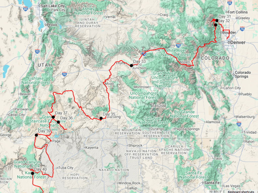
We meandered south towards I70 through Nederland and Black Hawk the next morning, before getting on I70 headed west towards the Eisenhower Tunnel. I’d always wanted to detour over Loveland Pass instead of going through the tunnel, so we climbed and climbed to 11,990ft. We did a short hike up the ridge east of the pass, gasping for air if we moved too quickly. Despite our hike the day previous, we were still definitely not acclimated! Back in the jeep and headed down the south side of the pass, we were shocked to see that some of the higher ski resorts were already open- even if all the snow was man-made! The lengths that people will go to in order to downhill ski always astounds me.
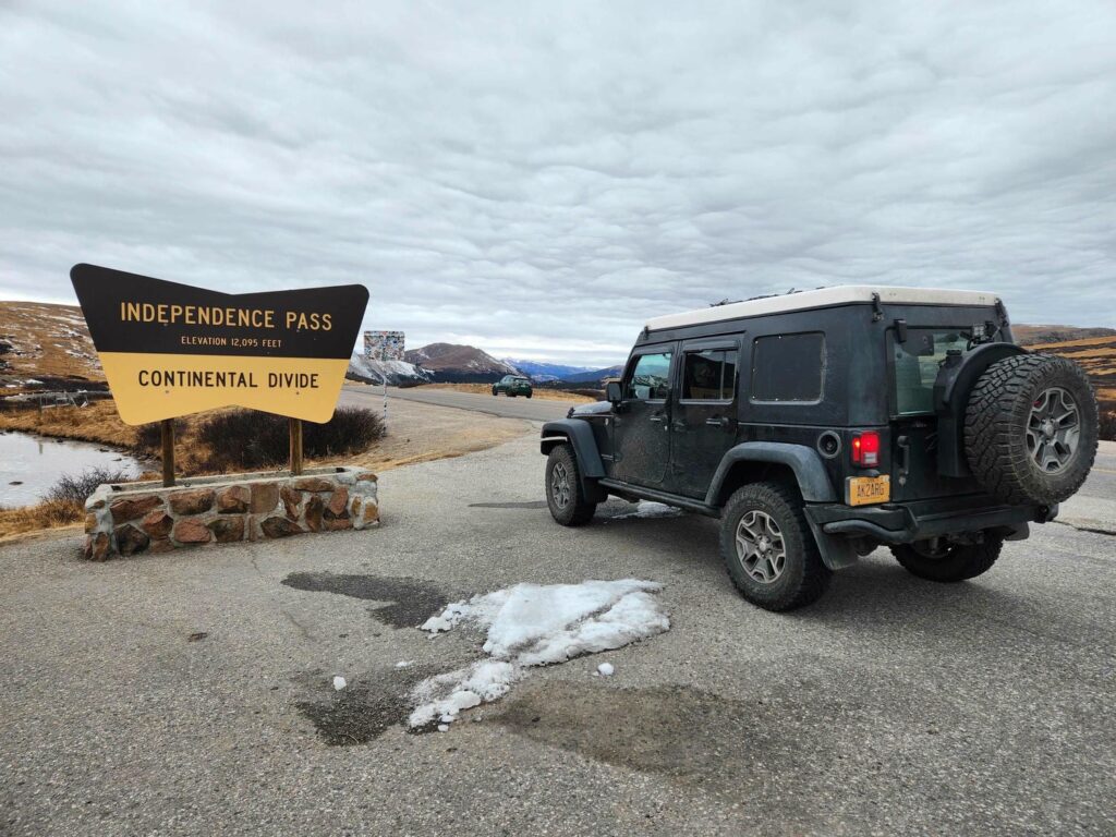
We met back up with I70 at Silverthorne, before leaving it again headed south on Highway 91 towards Leadville. Independence Pass had not yet been closed for the winter season, so we headed on up. It was very chilly up on top, with evidence of recent snow everywhere. It is crazy to think of people in the early 1880s building a road up and across. The road was much narrower on the western side, with rocks overhanging the pavement everywhere. The houses and apartments in Aspen were crazy- so much wealth is here! It was a bit telling that all the traffic was either brand-new SUVs or beat-up tradesman trucks, with really nothing in between.

We made it down to Grand Junction as in the early evening, and had a great time catching up with our friend Duane, his wife Hannah, and their 5-day old newborn! The next two days were wonderful- lots of time with the newborn Arthur, catching up with Duane and Hannah, and picking up the last of our packages- this was the last address we could ship things to! I thankfully was able to replace our lithium battery that runs all the “house” side of the jeep, as it had began shutting off randomly a month ago in the Yukon. What a relief to know that our fridge would run all night, now that we would finally be entering warmer climates! I also got a new set of tires put on, a bit taller and quite a bit narrower than the last ones. Hopefully these will last the duration of the trip- they are meant for one-ton trucks.

Leaving Duane and Hannah was bittersweet, as they were our last tether to a “home” anywhere that we will see for the next 1-2 years. It was very odd to think about this, as we left Grand Junction headed for Moab. We took the old canyon road south of Cisco, UT, which follows the Colorado River for miles in a deep canyon. On the south side of Moab, we stopped by Trail Mater Offroad Recovery. They have an awesome YouTube channel that I’ve been following for years, and I’ve picked up quite a few offroad tips & tricks from them. The crew sadly weren’t there, but their recovery vehicles were! They have 3 ridiculous off-road tow trucks, and a few other rigs that they use to recover broken rock crawlers, bogged down vans, and lost dirt bikes. It was so cool to see in person the vehicles that I’ve watched online for years! Seriously, if you have any interest at all in fascinating vehicle hijinks, this youtube channel is amazing.


We rushed off further south through Blanding to a campsite that I’d stayed at nearly 10 years earlier with Mike Wise, but I had visited the area in 2018 with my brother Michael. We got to the site in complete darkness, and the stars that night were amazing. We woke to an amazing desert sunrise, and I told Delaney the story of how Mike and I had found some native american ruins all those years before. In the spring of 2016, Mike and I had come to the area on a spring break trip my freshman year of college. We had intended to find some ruins that Mike had heard about, but the ruins weren’t on Google Maps. We got to the place and couldn’t find the ruins, so we set up camp. The next morning, we wandered around on top of the mesa to no avail. We descended down into a dry wash, but the wash narrowed down to a sandstone canyon and went off a cliff. We packed up camp and drove to the other side of the canyon, and found a less steeply sloped sandstone canyon into the bottom of the main canyon. There it was- underneath the sandstone cliff we had been standing on top of- a mostly intact native american tower. The tower had two stories, with the second story floor made of wood that had been grouted into the rock walls of the tower. There were also quite a few petroglyphs carved into the rock, including what looked like snakes, antelope, and humans. I’m sure the site is known to archaeology, but it was thrilling to feel like we “found it”, especially when the site is not well traveled.


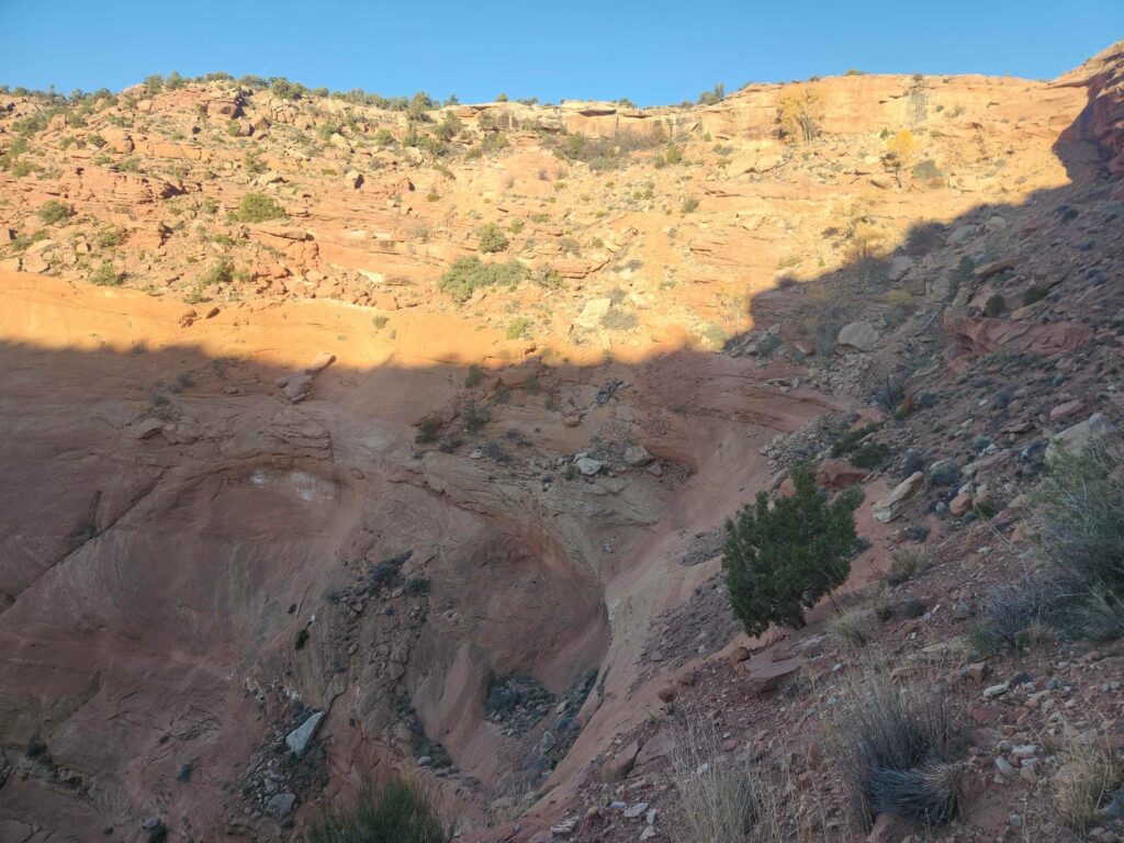
As I told the story, Delaney and I drove from our campsite to the trailhead, and dropped into the sandstone canyon. The site was nearly unchanged, and we marveled at how a family must have lived here, hundreds of years ago, deep in a canyon. After wandering around the ruins, we headed back to the jeep, and drove down the trail. I believe the trail used to be the main highway between Hite and Blanding, before the current highway 95 cut through Comb Ridge. The trail is in pretty bad disrepair at this point, and we were glad we had the 4×4 capabilities of the jeep! The trail switchbacks down a small valley incising Comb Ridge, with several smashed up vehicles down at the bottom doing nothing to improve our confidence. The vehicles are all very old, but well preserved by the dryness of the desert.

Successfully descending the trail, we got back on the main highway and headed towards Hite, a ghost town submerged under Lake Powell, and now a dry boat launch due to Lake Powell’s subsidence. The desert landscapes around Hite are simply stunning, with high sandstone domes, narrow slot canyons, and spindly spires of rock. It is unreal how much it looks like a Roadrunner cartoon! We climbed north out of Hite through a gorgeous canyon, and an hour later made it to Hanksville, where we met up with my cousin Ben! Ben has been living and working out of his super cool 1989 Astrovan Tiger- an astrovan with a fiberglass and aluminum camper body added to it. The company that made them still exists today, and they use 3/4 and 1 ton truck chassis for their campers now, but with the same construction- aluminum framing & siding, with a fiberglass top. Ben and Delaney and I had been planning for months on meeting up out here, and we were all so glad it worked out! We headed through Capitol Reef National Park to Torrey, and then south to Boulder. The road between Boulder and Escalante is in my opinion one of the most scenic in the lower 48, and we couldn’t help but stop at nearly every pulloff! We headed down Hole-In-The-Rock Road, an old Mormon pioneer route, hoping to be to some slot canyons before dark. We made it before the sun dropped below the horizon, despite 30 miles of horrible washboard roads!


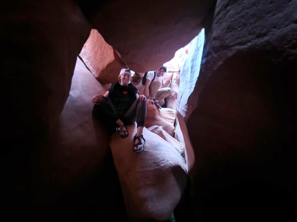
The slot canyons we’d been rushing towards are called Peek-a-Boo and Spooky. The route goes up one canyon, and drops back down the other one. They are both non-technical, but quite tight! There are a few sections where we could barely pass through, even sideways, both chest and back touching opposite sides of the canyon. We had a fantastic time, but we were a bit rushed due to dusk falling as we entered the second canyon! It was well and truly black out when we made it back to the trailhead, elated that we’d managed to do both before night. We found camp not far away, and had a big dinner all together, staying up far too late talking and laughing.


We woke the next day with plans to drive out to the end of the road- the hole in the rock. The jeep was doing a bit better on the washboard roads than the van, so we all piled in for the drive. We rattled on down, with another 30 miles of horrible washboard to contend with. At the end of the road is a canyon that the Mormon pioneers had enlarged in order to get their horses and wagons down to what was at that time the Colorado River, before going up the other side. The original trail, blazed in 1880, had been used to colonize Bluff, UT. We spent an hour or two at the end of the road, looking out over Lake Powell and the crazy desert landscape.


Back in the jeep, we rattled all the way back to Ben’s van, and found a great campsite near the Harris Wash trailhead. We left the van at the campsite, and piled back into the jeep again to drive out towards the Cosmic Ashtray. Mike Wise and I had been there before, years back, but the road had been closed at the Harris Wash Trailhead. We had hiked almost 10 miles roundtrip, in the hot summer sun, to see this geological oddity. The road was open this time, so we were able to drive nearly all the way! We were thankful we had the jeep’s 4×4 capabilities- the van, though it does have 4×4 with low range, would not have been happy with the deep sand.
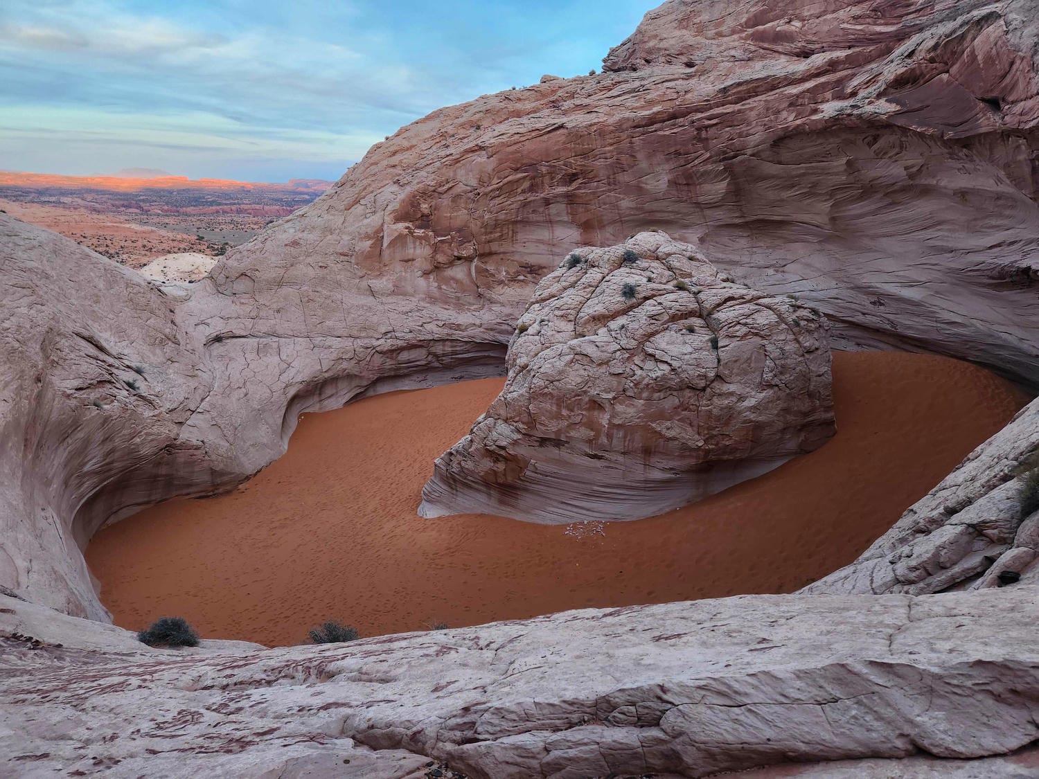
We found a good parking spot off the side of the sandy track, and talked to a retired park ranger who passed by. He had worked for years as a ranger catching poachers in Wrangell St. Elias in Alaska, before finishing his career in Escalante! Small world!. We then started up the sandstone dome. After one small wrong turn, we headed back down that sandstone dome and up the correct sandstone dome. Near the top, part of the dome has been hollowed out. Geologists aren’t completely sure how, but there is a pit, of stupendous size, carved into the sandstone. The pit, roughly oval in shape, is roughly 300 ft x 150 ft, with the vertical walls being well over 100 ft tall, other than a small cleft that stands at maybe 40 ft. The pit is full of bright orange sand, surrounding a huge white sandstone pillar in the center- the “cosmic cigarette butt” in the Cosmic Ashtray. Moki steps have been carved into the lowest wall in the cliffs surrounding the pit, so we all clambered down, marveling at this insane geological oddity. Much of the rock surrounding the pit even overhangs it, making it feel a bit like being inside a sandstone fishbowl. Ben remembered that he had left a frisbee in his backpack, so we all played catch for a bit. There was plenty of room for the 3 of us to play catch in the pit, even though we were only using one side of the Ashtray! Perhaps we were the first?


One of the many things that makes the Cosmic Ashtray so befuddling to geologists is that it is near the top of a sandstone dome, hundreds of feet above the valley floor. They agree that it has been polished by wind-driven sand, but how had the pit started? Was it water? Had wind-driven sand somehow carved out thousands of tons of rock? We may never know, but it is such an interesting geological feature to ponder on. We clambered back down to the jeep, and were thankful that we had not had to hike the whole way- we never would have had enough time.


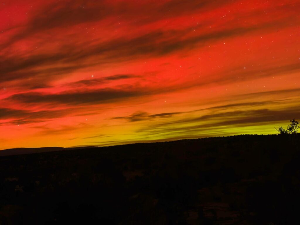
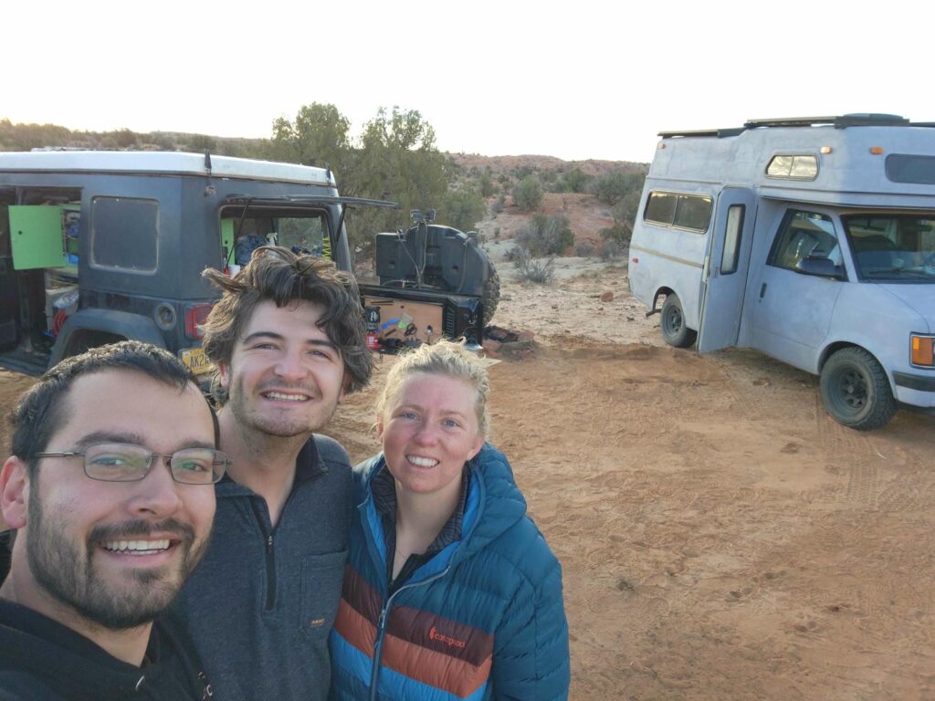
After a simple dinner back at camp, Ben noticed a strange glow in the sky. After a bit of puzzling, we figured out that it was the northern lights, visible in southern Utah! Ben had brought a camera tripod, so we each tried getting decent shots of it. With a long camera exposure, we were able to see brilliant reds and greens. This display was apparently the best of the year, and we had noticed it by chance! The next morning, Delaney made breakfast for all of us, and we all got to work. Ben had his real job, while Delaney and I picked away at various jeep tasks. I replaced the jeep’s hood latches with some stouter aftermarket ones, Delaney finished sewing some covers for our mattress, and then all three of us together barely managed to replace the struts for the jeep’s pop-up roof that I had picked up back in Wisconsin. The gas struts are extremely strong, and had to be compressed a bit to fit on. We would not have been able to do it without Ben’s help! We also turned on our Starlink dish for the first time- after very little effort, we had internet! After the work for the day was done, we gathered some firewood together, and had a blazing bonfire to cap off the night. Ben thankfully had picked up some whiskey and ciders in town, and Delaney made a delicious stir-fry dinner. We stayed up late talking and enjoying the warmth of the bonfire in the cold desert night.

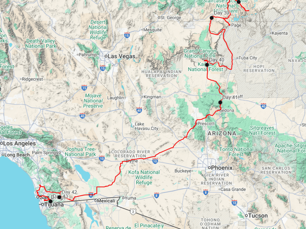
Ben departed early the next morning for Colorado, and Delaney and I headed south for Page, AZ, through some back roads that I had always wanted to drive. We were truly without any schedule at all at this point, for the very first time. We eventually found ourselves on Smokey Mountain Road, aptly named for a coal seam that has been on fire for hundreds or even thousands of years. Cracks in the ground smouldered with an acrid smell as we peered into the smokey holes in the ground. Two geological oddities in as many days!


We ate lunch at an amazing overlook, before heading down the Kelly Grade, apparently named after the only bulldozer operator crazy enough to carve the road. The road descends from a high plateau, nearly 2000ft down, hugging the crumbling cliffs all the way. The road spilled us out onto Highway 89 in Big Water, UT, and we soon crossed the border into Arizona on our way to Page. We restocked on food and fuel in Page, before heading back up Highway 89 and then down The Cockscomb, a road that parallels a geological feature of the same name. The Cockscomb is an over 40 mile long ridge, trending uniformly north-south, formed by faulting and tilting of layers of sandstone. It is unusual, as most of the Colorado Plateau (a geological region larger than Arizona, centered roughly on Four Corners) is a uniform block, without faults, folds, or tilts in its mostly uniform sedimentary beds. Erosion of the red rock ridge has formed points, which look very similar to a rooster’s crest- hence, “Cock’s Comb”.

We found a great campsite high above the road on a rough trail accessing some power lines that serve the Glen Canyon Dam in Page. The next morning, we drove south past some trailheads that I would love to come back to- Buckskin Gulch, the longest slot canyon in the world, and the Wave, a gorgeous sandstone feature that is now so popular that there is a lottery system in place to visit it. Next time! We did stop at a small parking lot that has a view of a California Condor release station. California Condors were nearly extinct by the mid 1980s, and all surviving birds, totaling just 27, were captured by 1987. A successful captive breeding program saved the species, and now the species is breeding in the wild again, but reproduction rates are slow. Fewer than 600 are alive today, with each one wearing a number and a radio tracker. We were able to see around 15 condors perched on the release station high above on the Vermillion Cliffs, 3 miles away. Delaney also spotted a few that were perched away from the station on the cliffs. It was difficult to gauge their size (nearly a 10 ft wingspan!) through binoculars and camera from such a distance, which makes me very excited to see Andean Condors, their closest living relative, in South America!
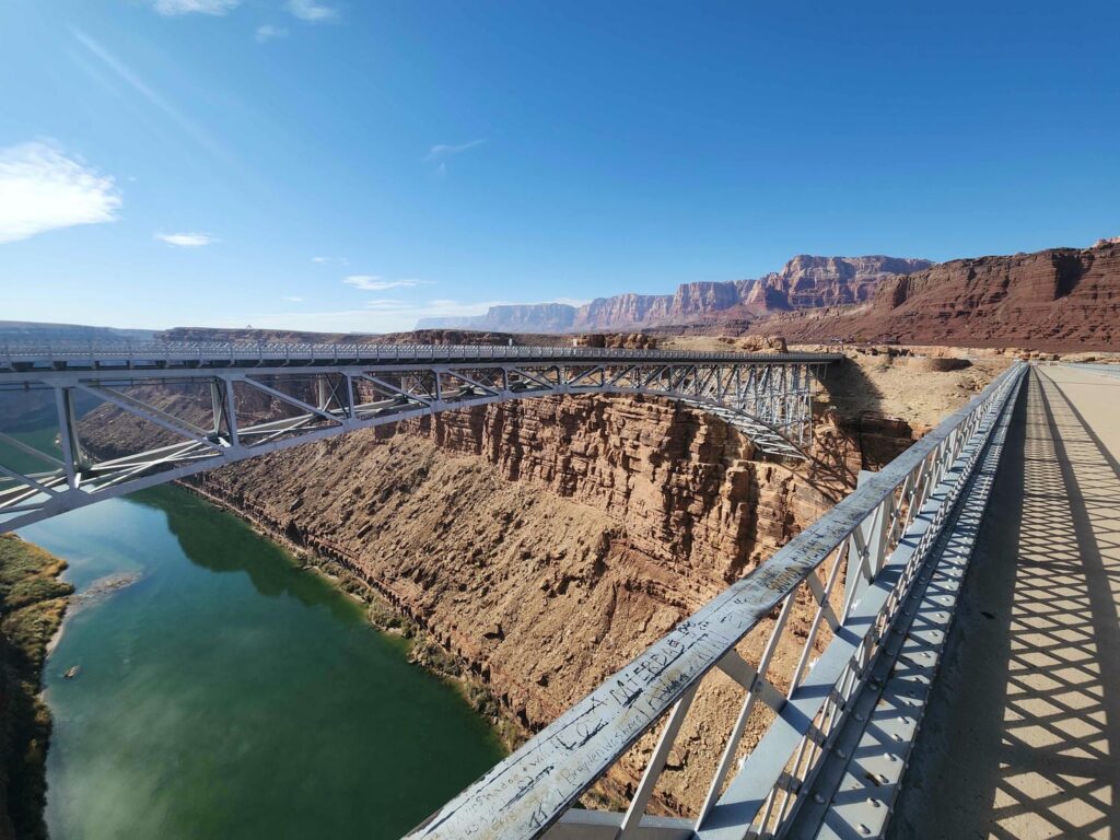
We headed east on Highway 89A towards Marble Canyon, and stopped at the Navajo Bridge, which before the Glen Canyon Dam was built was the only crossing of the Colorado River for 300 miles in either direction. The bridge, now for pedestrians only, was an amazing feat of engineering for 1929. The bridge is only a few miles downstream of the put-in point for those rafting the Grand Canyon, with no other river access available until downstream of the canyon. Even here, at the beginning of the Grand Canyon, the river is already some 200 feet below the rim! We moved on through Bitter Springs, south to Cameron. This area is extremely poor, with lots of run down houses and trailer homes sitting out in the desert. After being slowed by an accident just outside of Cameron, we turned west towards Grand Canyon National Park.

We stopped at the entrance sign to get a picture of the jeep- I had been to the Grand Canyon before, but in Mike Wise’s yellow Subaru Baja. We hurried out of the jeep at Navajo Point to get our first view of the canyon. What a spectacle! It boggles the mind how large in every direction the canyon is- it almost looks fake, like a trick of the mind. Countless pink and red ridges faded off into the distance as the haze grew thicker in the sunset. We climbed the “watchtower”, a structure built by some of the first entrepreneurs at the canyon, made to closely resemble a Native American structure, before returning to the jeep to get to the next viewpoint. We stopped at Moran Point for some time, but realized that if we were to find a campsite while it was still light, we would need to skip the rest of the viewpoints and go the next day. We hadn’t really intended to spend more than an afternoon here, but we had arrived later than we had hoped, and we had no particular schedule! We miraculously found a perfect campsite only a few miles from the western entrance station- turns out traveling in the “offseason” has its benefits!


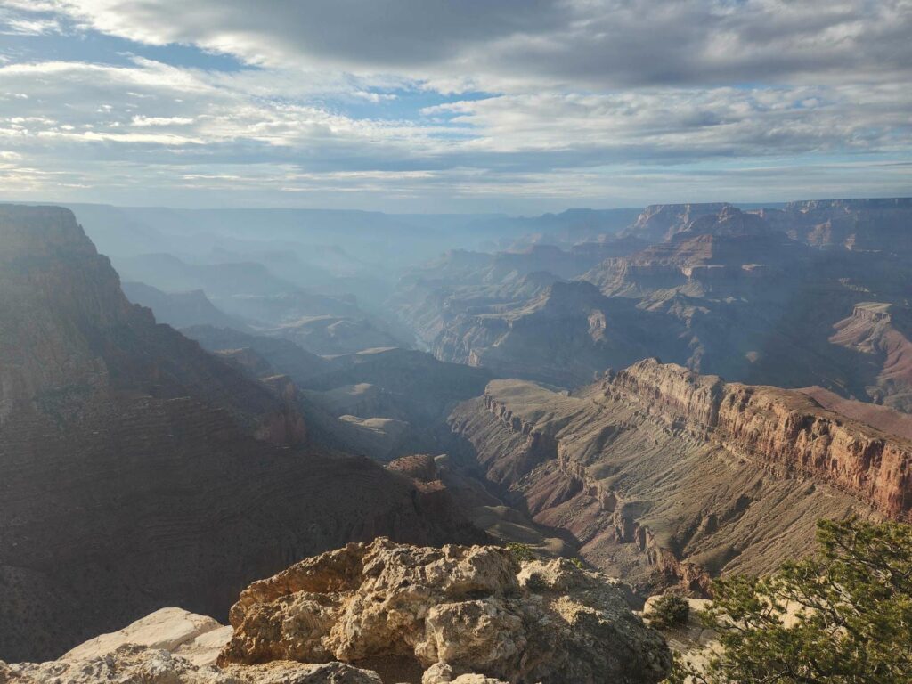
The morning sunrise was incredible, and it looked to be a great weather day for us. We had decided to to the Rim Trail, which follows the canyon rim from Hermit’s Rest over 10 miles east to Yaki Point. We took the bus out to Hermit’s Rest at began hiking back east. The hike, while offering stunning views of the canyon, did manage to get a bit boring after a while. One can only look at this unbelievably vast gouge in the ground from so many different directions before it becomes a bit monotonous. We enjoyed Powell Point, which hosts a monument honoring John Wesley Powell, a one-armed army major who led the first expedition down the canyon. He is also notable for leading the first expedition to summit Longs Peak in Rocky Mountain National Park. Delaney is from Powell, Wyoming, which is also named after him.
A nearby viewpoint tells the story of a copper-turned-uranium mine that had once existed on the edge of the canyon, and was the richest uranium mine in the world for a time. We were a bit disappointed that the Park Services seems to be gloating about being able to shut the mine down, and really vilifies the mine owner. Some signs around the Bright Angel Trail also vilify the original owner of the trail, and imply he was evil for charging a 1$ toll to cross what was at the time his mining claim to get down to the river. The Park Service, after a long legal battle, assumed control of the trail in 1928, when the 1$ toll would have been about $19 in 2025. I thought the whole thing was a bit ironic considering one cannot enter the park and see the canyon at all without paying a $35 entry fee!
Griping aside, we really enjoyed the hike and highly recommend it. We chose to take the bus back from the Bright Angel Trailhead to the visitor’s center to save time. The visitor’s center wasn’t particularly notable but the Yavapai Geology Museum a mile away was exceptional. The museum sits on the canyon rim and explains very clearly how the canyon was formed, and we thought that Yavapai Point outside the museum was the best view of the canyon. We were able to see down to the river in a few places, including the Black Bridge which carries foot traffic across the river to Phantom Ranch at the bottom.


Starving after a long day, we drove south to Flagstaff and put a Texas Roadhouse gift card that I’d been hanging onto for years to good use. While waiting for our table, we also went across the parking lot to a Sportsman’s Warehouse and picked up a small day pack- we each have our large backpacking packs but they are a little large for the short 1-4 mile excursions that we end up doing pretty often! Full of prime rib, we headed south from Flagstaff in the dark and found a camp up a forest service road off of Highway 89A just before Oak Creek Canyon. It poured all night, and we woke up to our camp spot slowly filling with water! We beat a hasty retreat back down to the highway and headed towards Sedona. The rain dumped down on us, obscuring most of the views. This area seemed really beautiful, and we’ve made a mental note to return here someday. We passed through Sedona and stayed on 89A up to Jerome, now mostly a ghost town after the Gold King mine was exhausted. We passed through Prescott, and stopped at a monument near Yarnell to 19 firefighters who had perished in a wildland fire in 2013. This whole area, from Flagstaff through Yarnell, was absolutely gorgeous and we will return someday. We turned south at Blythe, California, but not before filling up our fuel tanks to the brim- fuel in California was almost double what it was in Arizona! To my surprise, we passed through the Glamis Sand Dunes, a dune buggy paradise, and resolved to return here also to rent a buggy for a day or two. We got In-n-Out at El Centro, before climbing the In-Ko-Pah grade nearly 4000 vertical feet up from below sea level. We struggled a bit to find a good camp spot- our first two tries were no good. California has a nasty habit of closing forest service roads to the public, and we were kind of expecting a bit of a hard time, but not two hours of looking! We did finally find a spot near Corral Canyon.


The next morning was an errand day. We had a few things to do: visit our bank office, get some Chik-fil-a, get a few nuts and bolts, visit REI, get In-n-Out again, and finally exchange dollars for pesos. I was pretty frazzled after driving around San Diego all day! We did manage to get everything done on time, and found a much better campsite in the Otay Mountain Wilderness. The next day was a “project” day- I installed all the nuts and bolts we’d bought the day before, we switched up our phone plans in preparation to enter Mexico the following day, and finally ran back down into town because Delaney couldn’t change her phone plan over the phone- only in a store! We were a bit annoyed, but we had planned on heading down to a nearby lake anyways to fill up on water. We filled up our water tanks in the drizzling rain, and went back to the same campsite again for one more night. We would cross to Mexico in the morning!
So exciting to read all your adventures. I feel like Im getting a geology and detailed history lesson…but…much more interesting and no test at the end. Great pics…keep them coming