We drove across the border bridge into Honduras, and had our passports stamped into the country. We had a bit of trouble finding the Aduana building to get the jeep paperwork done, but we finally found it a few hundred yards down the road. This paperwork took a while- there were lots of questions, such as how heavy the jeep was, how many cylinders it had, what fuel it took, and how much it was worth. The Aduana clerk worked at his computer for nearly 45 minutes before passing us our Temporary Import Permit for Honduras, and we were free to go.
We stopped in Ocotepeque to refill on some groceries, get some Honduran cash (“lempiras”), and pick up a few groceries. Usually we try to get out of border towns as quickly as we can, but Ocotepeque felt very safe, so we decided to just get an early lunch here. I’d wanted to try a fried chicken chain, Pollolandia, that I’d seen in Guatemala and El Salvador, and there had been one just a few blocks back. We got an enormous amount of food for the $10 we paid and had plenty of leftovers! I had a bad KFC experience years and years ago and haven’t been back, but I love fried chicken and Pollolandia was delicious.
We drove out of Ocotepeque on a wide highway, climbing rapidly. The highway was beautiful and smooth, but very new- there weren’t any lane lines or markings whatsoever. After climbing up and over our first of many Honduran mountain passes, we had a decision to make. We were headed for Copan, another Mayan ruin, the last that we would see. We could either go the long way on the nice highway, or take a “shortcut” through the mountains on a rough dirt road. We of course chose the rough road! It was beautiful, and climbed up and down, over and over again, through the central Honduran mountains.
We passed tiny village after tiny village, each one beautiful and clean. The road shrunk from a nice and wide dirt road, into a small two-track at times. There were a few washouts here and there, and though none were too bad, I wouldn’t want to drive this road in the rainy season! There was a broad braided river that we had to cross, and it reminded us a lot of some Alaskan river crossings we’ve done, though the temperature and foliage were much different. The road took us a few hours, and it probably wasn’t any faster than if we’d taken the main highway, but we got to see some beautiful scenery at a slower pace. We finally reached the main highway on the north side of the shortcut, and just a few miles later and we reached Copan.


We’d made quite a detour to reach Copan, and we hoped that it would be worth it. Copan is just a few miles from the Guatemalan border, in the very western corner of Honduras. There really weren’t any other major things in the country that we wanted to see, so we’d really come out of our way. Most other overlanders just go southeast from El Salvador straight to Nicaragua, bypassing almost all of Honduras.
Right across the highway from the entrance to Copan is a small campground, run by Mauricio and his family. It turns out Mauricio is Copan “royalty”- his family owns a huge amount of land in the area, and he is also related to the mayor of Copan Ruinas, the nearby colonial-era town. He grew up nearby, and told us all sorts of stories about the excavation of the ruins and how things have changed over the last 50 years. He was an incredibly gracious host, and our stay there was possibly our favorite paid campground so far.
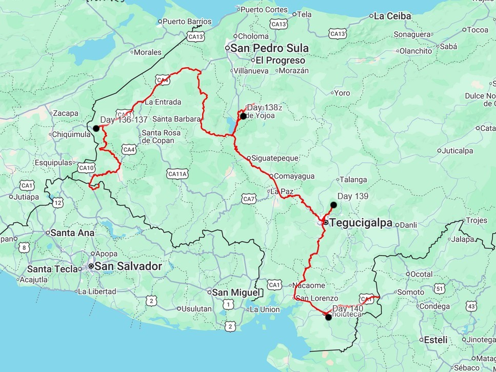
We’d just settled in and began cooking dinner, when we heard some raucous calls overhead. We looked out over the valley and saw a bunch of Scarlet Macaws flying by- they were huge, the size of Bald Eagles, and bright red! Some later landed in a tree not 30 feet from us. It turns out that they are very common here due to a captive breeding program that has been very successful after near-extinction in the area. They were very abundant when Copan was an active city, as evidenced by all the carvings and sculptures of them in the ruins.

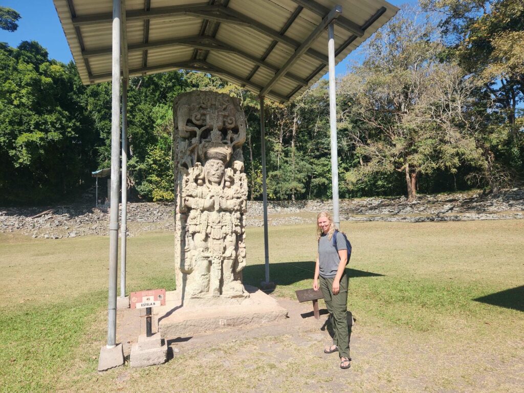
We had a peaceful night and walked across the street in the morning to visit the ruins. The tickets were fairly expensive at $20, but well worth it for us- Copan is my favorite of the eight Mayan ruins we visited, and Delaney’s second favorite, behind Caracol in Belize. We wandered down a now-familiar Mayan causeway into the central plaza, with Scarlet Macaws everywhere. Copan is not famous for massive pyramids or extensive acropolises, but for its intricately carved stelae and amazing stucco reliefs, which seemed to be plastered onto every surface.


It has been said that if Tikal was the Maya’s New York City, Copan was their Paris- full of artists, craftsmen, and dreamers. The main plaza had perhaps 8 massive stelae standing out in the open, larger than any we’d seen so far, and very different than all the others. The stelae at Calakmul, Caracol, and Tikal had been mostly flat chunks of rock, with a shallow relief image of a warrior or king on the front and back, and Mayan writing on the sides. The figures carved into those stelae were raised off the surface of the rock by half an inch at most, probably closer to a quarter inch. The stelae here at Copan were in full relief- it was as if the slab of rock had been turned into a sculpture, rather than just having an image on the surface. Each one was the figure of a king or warrior, standing over 10 feet tall.


We marveled at the stelae for a while, before wandering through the ballcourt and over to a pyramid that was covered by a massive awning system. The awning was covering the front stairs, known as the “Hieroglyphic Stairway”. Every stair step is covered with Mayan lettering, which is still being deciphered and restored. It is the longest known Mayan text. We then explored the main pyramid structure, which consisted of several pyramids, plazas, and other structures. None of the structures were particularly tall, but together they were incredibly massive- such a huge amount of rock stacked up!


There are many tunnels through this main structure, all dug by archaeologists over the years. Some are open to tours, which we had heard were a bit underwhelming, so we didn’t purchase these along with our entrance tickets. One thing that the tunnels tour does allow you to see, however, is the Rosalia Temple.


Mayan temples were not built as a “one-of”, as the Egyptian pyramids were- they were added to, remodeled, and modified over the centuries. The Maya would take a complete temple, and build a new temple right over the top, without disassembling the older one. One of the pyramids at Copan is the result of building a new pyramid on top of the old one seven times in a row. The 5th layer is the Rosalia Temple, discovered during tunneling in 1989. The temple is remarkably well preserved, with elaborate stucco reliefs, paint, and roof comb held in place as a new temple was built over the top. Small portions of it can be seen during the tunnels tour, but a life-size replica has been built and is in the nearby museum.


Another amazing artifact uncovered here is “Altar Q”, a stone block about 2′ x 2′. It names and depicts the first 16 leaders of Copan after its refounding in 426 A.D., up through 763 A.D., spanning nearly 350 years. I say “refounding” because the Copan valley had been occupied for potentially thousands of years prior to 426. However, an outsider became ruler of the area then, starting a new dynasty. Remarkably, the altar also says that this first leader of Copan came from near Teotihuacan, near what is now Mexico City. There is some evidence of a coup happening in several Mayan cities around this time, including Tikal, all originating from a group that may have been outcast from Teotihuacan. Many of the other sites we’ve been at have discussed royal lineage- it is amazing to read how the leader of Caracol married someone from Palenque, or that the leader of Copan married someone from Tikal, or that someone from Lamanai married someone from Teotihuacan. The Mayan world was amazingly connected in a way that archeologists still don’t quite understand.


After spending several hours wandering the main ruins, we stocked up on water and had a brief lunch back at Mauricio’s. We then walked a mile or so down the main highway to another section of Copan- the Sepulturas, so called because of all the burials found here. This was a separate city center outside the main Copan ruins, which had apparently been the home of some important artists and scribes. While reading the entry signs, we were approached by an elderly local man, Daniel, who began explaining some of the pictures and diagrams. Before we knew it, we were following him into ruins. We’d avoided guides at all the other ruins, but at this tiny little outlying ruin we’d been “tricked” into it! He had been around for a long time, and had helped out with excavations for decades. He didn’t speak any English, but we enjoyed the tour around the site and really got a lot out of it. None of the buildings were very impressive, but he would show us things we hadn’t noticed before at other ruins- alcoves where candles had been placed, holes cut into the rocks to attach doors or curtains to, and places where burials had been found. We were happy to give him some money for his time, which he was very thankful for.
After walking around the Sepulturas for much longer than we’d expected, we were quite hungry and tired. We walked back to the campground, and then kept going past it for a mile or two to the town of Copan Ruinas. We enjoyed dinner at a nice restaurant after walking for the entire day- I had grilled chicken and Delaney had an incredible steak. It was less than $20 total! We’d been told by Mauricio that the town was completely safe, and we felt like it- all sorts of families walking around, Catholic mass was being said in a nearby church, and teenagers hung out in the park. We normally don’t like being out after dark, but we didn’t mind it at all here, and enjoyed our night out.
Mauricio had told us the day before about a hike up the hill behind his house, so we got up early and started off. He had said that he’d found all sorts of Mayan artifacts back there, including tools, obsidian, and pottery. We didn’t find anything, but we had a great hike up through a cow pasture and then bushwacking through tall grass to the top of the hill. We then had a 360-degree view over the whole Copan valley, which at its height around 800 A.D. had supported around 25,000 people. We could see the top of the largest pyramid down at the ruins site, as well as the large plaza where all the stelae stood.


When we got back, Mauricio wouldn’t let us leave without having us try on a bunch of headdresses he’d made out of macaw feathers. We’d seen some at the ruins the day before, with someone charging a few dollars to take a picture in them. Mauricio said that he had made those too! It was definitely touristy and silly, but it was good fun. He had us do all sorts of poses, fighting each other or fighting a dried snake that he would hold in front of the camera to make it look huge. In a previous life he’d been a tour guide in Hawaii and Italy, and he seemed quite adept at setting up goofy tourist photoshoots.


We had a long drive day ahead of us, so we said goodbye to Mauricio and headed east. The terrain in Honduras is mostly jungle-covered mountains, which meant for a lot of ups and downs! We drove through Santa Barbara and then around the south side of Lake Yojoa, the largest lake in Honduras. It seemed to be quite the tourist attraction, with all sorts of shops and restaurants lining the lake. We camped at a private nature preserve, Luna del Puente, another 10 miles past the lake. We arrived pretty late, and were thankful to be at a higher elevation than Copan, where it was much cooler.


Delaney ate breakfast at the small on-site restaurant in the morning, while I looked for birds and tidied up the jeep. I didn’t get to meet them, but one of the workers at the restaurant and her husband had done the Pan-American Highway on motorcycles about 10 years earlier! After saying our goodbyes, we drove a short distance up towards the El Cajon dam, which produces a large percentage of Honduras’s electricity. We were looking for the rare Honduran Emerald, a hummingbird that is Honduras’s only endemic bird species, but we sadly couldn’t find it. We headed back through the Lake Yojoa tourist area before starting a long drive to Honduras’s capital, Tegucigalpa.
The highway was in good condition, but there were a few construction areas that slowed us down by a lot. We were headed for Parque Nacional La Tigra, a large national park that could only be reached by going through Tegucigalpa. We’d heard that the city could be a little sketchy, and we weren’t too happy to be passing through it on narrow city streets as the sun was setting. Fortunately there really wasn’t a lot of traffic, and we made our way through the city and began climbing towards La Tigra through a very nice and presumably expensive neighborhood. The road deteriorated as we climbed higher through smaller mountain towns, until we’d left civilization behind. We pulled into the very full parking lot at the national park in darkness, and found one of the last parking spots. We hate driving at night and were glad to have arrived safely.
It was Saturday night, and we could hear a heck of a party going on at some of the cabins above the parking lot. So that’s why the parking lot was full! The party didn’t go too late and we got a good night’s sleep. In the morning, we did a loop on some of the trails through the park. The trails were old mining roads- the park had been the site of a large silver and gold mine in the 1930s, and with the wet cloud forest ecosystem, it felt a lot like an old Alaskan mining road! There were tall pine trees, thick underbrush, and lots of dripping moss and small streams. We really liked this area and would love to visit again sometimes and hike some of the longer trails!
We drove back down the mountain and all the way through Tegucigalpa, happy to be doing it in broad daylight this time. The city seemed to be a bit run down, but on the rise. Honduras has had a rough history, especially over the last 20 years or so. One thing that I noticed, especially in the wealthier areas, was that the properties were walled in, with razor wire lining the top of the walls. The razor wire was all rusty though, indicating that it was needed at one point, but the lack of “new” razor wire might mean that people feel safer now than they once did.
The roads through Tegucigalpa were crazy- narrow city streets that curved in fantastical ways, crazy on and off-ramps that defied logic, and amazing bridges across deep river valleys. The city was built into the bottom of a valley, but has expanded up into steeper areas in the hills. We were soon hurtling south on the highway, up and down across the many ridges and valleys that make up most of Honduran topography. As we’d seen in Guatemala, the temperature gradually climbed as we descended. We’d been at a blissful 55F for our night at La Tigra, but by the time we reached the coast at the town of San Lorenzo, it was over 100F. The temperature rose as high as 105F as we drove through Choluteca.
We’d found a promising campsite online, and drove through Choluteca and climbed up on a small farm road towards some communication towers overlooking the city. The road was incredibly steep and we definitely needed our low-range gears. After a small wrong turn that took us further into the mountains on some narrow shelf roads, we turned around and came to a gate we’d read about online. The family that owns the land beyond allows people to camp on their property for free, so we stopped at their house just before the gate to ask for permission. They were extremely friendly and seemed very excited that foreigners wanted to visit their property. We passed through the gate, and after another few hundred yards of extremely steep road, we came to a large flat area, just below all the communication towers. The area was set up with a pit toilet, benches, and a firepit- perfect for us! There was a simply incredible view of Choluteca and the valley below. We had only climbed around 1000ft above Choluteca, but the temperature was much lower, especially with a wonderful breeze that blew all night long. Both Delaney and I took the opportunity to call our families and catch up. We generally use Starlink to do this, which works amazingly for most web browsing and route finding, but it often drops calls when there are trees overhead. This spot was perfect, and I think we each spent several hours talking with various family.


The night was warmer than it had been at La Tigra, but with the breeze we slept comfortably. We woke early the next morning to meet our friends Dominic and Pia in Choluteca- we’d met them at a repair shop in El Salvador when we had our bumper welded back together. They had spent 5 days there while having a custom radiator made- it was cheaper and easier than getting one shipped from Germany! We’d discussed meeting up to ship our drones from Honduras to Costa Rica- drones are strictly forbidden in Nicaragua, and the penalties are steep if you are found with one. We met at the Choluteca DHL office, got the drone shipped with the help of the very friendly clerk who’d definitely shipped a lot of drones to Costa Rica, and caravaned down the road towards Nicaragua. The road climbed steeply out of Choluteca, and we passed quite a few laboring semi trucks. Before we knew it we were at the border town of El Espino, ready to leave Honduras and cross into Nicaragua.
Some final thoughts about Honduras: it really has a bad reputation in the United States, and I think that is not without reason. It has been through several revolutions, coups, and currency crashes in the past few decades, mostly because of corrupt politicians. Very few foreigners seem to visit- we saw almost no foreign tourists the whole time we were there. The app we use to find campsites and other information, iOverlander, has very few locations marked, compared to Guatemala, El Salvador, and even Nicaragua.
That being said, we absolutely loved our time there. The people were without exception extremely friendly, welcoming, and helpful. While we were parked on the side of the road looking for the hummingbird near Lake Yojoa, a car stopped to make sure we were ok. He was a lieutenant in the Honduran Army, spoke some English, and made sure that we exchanged contact information in case we ran into any trouble anywhere. The country as a whole was also clean, much cleaner than Guatemala or El Salvador. Finally, the natural beauty of Honduras is unmatched so far in Central America. So much of the country is mountains, covered by gorgeous verdant jungle. There are deep river valleys with torrents of water, foggy ridges with massive pine trees, and stunning vistas over the landscape. We will certainly be back someday.